Since the main body of CUCC hard persons were going to Austria the remaining hard drinkers arranged an expedition to the only place outside the U.K. with decent beer. The stated intention of the expedition was to open up 'whole new caving areas which have never been looked at...!'. Out of complete disarray a fortnight beforehand, four expedition members emerged:
Andy Nichols,
Julian Griffiths (who had been before)
Graham Hill, Andy Waddington (who hadn't)
We were joined for our second week by Team Austria, viz. Nick Reckert and Steve Perry, who had run out of insurance on their way to the continent.
We first went to look at a promising patch of blue on the map, Carboniferous limestone in Donegal, but we soon found that while the scenery was very nice, it was all above ground. We followed a couple of streams blithely flowing over the surface of this supposed limestone and it was quite clearly non-cavernous. As we drove south we read some of the literature we had aquired and soon learned that a little knowledge of the local geology explained things well.
The Carboniferous Limestone of Ireland is split up into three major divisions:
This stratigraphy was very evident in the Gleniff cirque where we went next, the Dartry Limestone forming spectacular high clean cliffs, while the Glencarr limestone formed only steep grass slopes. At the junction of the two limestones is a line of small, generally impenetrable risings at the base of the cliffs. The problem with the Gleniff area is that the impervious capping has been eroded away, so that there are no streams to sink. The most significant cave (the entrance is visible five miles and more away, and is 30m wide and 10-15m high) is Diarmuid and Grainne's Bed Cave (Dermot and Grania's) which is only about 500m from the road. Unfortunately it is about 300m above the valley floor. Once we had struggled up the hill, we found that the cave did not do its entrance justice, though it is quite nicely decorated with cauliflower-like concretions of calcite. Examination of this has shown it to be essentially the same as the moonmilk found in many caves in the U.K. Electron microscopy of the sample in Cambridge demonstrated its similarity to moonmilk from OFD. A report on this work should appear soon.
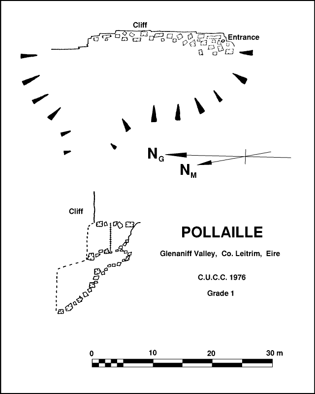
The climb to the top of the ridge is even steeper, breeching the cliffs at a convenient break. The top is devoid of impervious capping so the peaty waste is liberally dotted with shakeholes, none of which offer any prospect of penetrable cave although one or two look as though they might take some bog drainage water in wet weather. We knew that the area had been thoroughly combed by CPC, SUSS and others, so we reluctantly abandoned our excellent campsite and moved to Manorhamilton, a sleepy little town which acted as our base for prospecting in the Dartry Hills. This area was looked at by UBSS in 1956 & 57, and though Ramson's Pot has received considerable attention since then, we hoped that a systematic search might reveal something new. Two parties walked towards each other from opposite ends of the range, but unfortunately did not meet up in the middle - the section omitted seems to be the most looked at previously. In the north several stream sinks were noted, all impenetrable, and one seemed to be entirely in peat. At one sink, near Meenagraun Pot, the water disappeared into an impenetrable joint at the very obvious shale-limestone boundary. Nearby were several deep shakeholes. One in particular (noted by UBSS) is a massive collapse with a cliff face on one side. At the foot of this face there is a jumble of boulders, and at the right hand end Andy opened up a rather awkward hole in the boulders. A ladder was dropped down, and a way on was followed down into a small boulder chamber with a further hole leading down through the choke and into a larger boulder chamber which extends a short way along the cliff face. Digging here could produce a way into some cave, but to be safe, shoring would be vital. We sketched the discovery and moved on. The lowest point reached was about 35' below the entrance, probably 25' below the bottom of the doline. This must be about 50' below moor level. However, a permanent rising was noted by UBSS some 150m away, so the potential is not great. Perhaps a dye test could confirm this. While the hole has been noted before, we found no evidence of previous penetration. We decided to call the pot Pollaille, since the overhanging cliff is the most prominent feature. We found nothing else of interest before arriving at Polldinna, except for one stream sink which obviously could not cope with all the water it takes in wet weather - there is a rocky gorge cutting down the side of the main valley , but the rock is extremely cherty and nothing is penetrable.
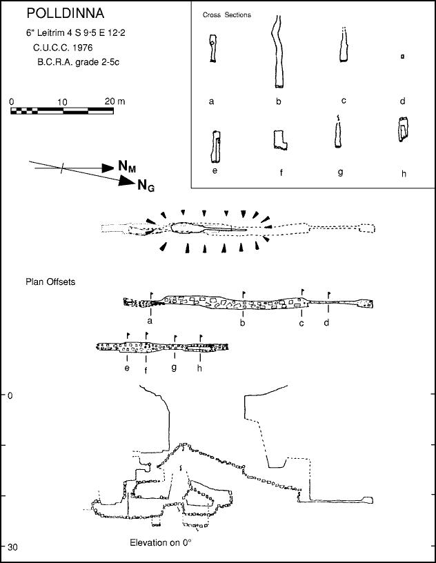
Polldinna, or Asthma Pot, is an evil rift in a tree lined shakehole with no good belays. A bolt was placed, and used together with a stake for security. An interesting hole in the boulders was noted at the south end, and this was descended when we returned to survey the pot near the end of the expedition. The section beyond this hole in the boulders was surveyed single handed to grade 3 by Julian while Andy W sat above listening anxiously to numerous rumbles and crashes of boulders from below. The open pot was surveyed to grade 5c. Suunto compass and clino with Fibron tape were used for all the surveys.
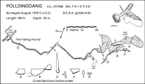
In the south no new pots were found, despite inspecting several hundred shakeholes. The first pot that we came across however was Polldingdang (not to be confused with Polldingdong near Dromahair). The entrance is a double shakehole connected by a rock arch. Below this is a 20' drop. A short handline would be best here - the first section is an easy climb, but the bottom section overhangs, and the cherty holds break easily. We used a 20' ladder here since this was the tackle that was most available at the time (I like that one...Ed), and this proved very convenient. It is described by UBSS as ending in a muddy choke after 80' of passage. Not knowing this at the time, Andy Nichols dug a small hole at the bottom and squeezed the executive frame into a roomier crawl beyond. Bits of crawl insist on falling onto one, but he eventually reached a small chamber where he stepped onto a very obvious foothold below. A large crash indicated the collapse of the foothold and a good part of its supporting wall. Andy retreated. Julian and Andy W returned later to survey the find, and the chamber was cautiously entered. All leads from it choked, and as we were about to leave, a large chunk of the wall collapsed, gashing Julian's finger. We dug the survey gear up and quickly started to survey out, leaving bloodstains everywhere. Various side passages were investigated, but none showed any promise. At some time there has been a very substantial stalagmite floor in the upper part of the cave, and a large group of flowstone blocks now litter the boulder area.
After Polldingdang, we failed to find anything new, though we did discover that the pitch length of 112' quoted for Ramson's Pot only gets you to the ledge. This pot is a patch of rank jungle in a large depression on the moor, and in this jungle is a deep hole. The belays are to slimy boulders a long way back and do not inspire confidence. The pitch is about 130' to the floor so our 120' rope was insufficient. We could not even reach the ledge so we abandoned our trip. After this, we returned to Manorhamilton. Friday 13th and Guinness number 3 was taking effect when the obvious next move was thought of, suggested and acted on all within 10 minutes. Six hours later, we were all sitting comfortably in O'Connor's Bar in Doolin. At this stage Team Austria appeared having taken a wrong turning on the way to Austria. Expedition drinking strength increased. There followed a week spent tourist caving in Fergus, Doolin, Cullauns 3 & 4, Coolagh, Pollballiny and elsewhere, plus sunbathing, swimming and of course inhabiting O'Connor's bar. We expected and found nothing new but the week was very enjoyable.
On the way back north, Julian and Andy W. stopped off at the Aille River Cave, a sportingly wet system in Co. Mayo. After a day surveying at Dartry, we returned to Larne via Marble Arch, though lack of knowledge precluded a visit to Legnabrocky way.
Andy Waddington