| CUCC Home | ||
|---|---|---|
| Previous: Betzulako Harpia |
CU 1974 Contents Page | Next: Digging in a Doline |
Following the tradition of the last two CUCC Pyrenees expeditions, several members spent about a fortnight looking for the entrance to the Rivière d'Arrigoyena. This is the system predicted by geologists to run parallel to the Gouffre de la Pierre St. Martin, the deepest cave in the world. The existence of a large resurgence separate to that of the Pierre system, with a deeply cut dry valley leading down to it from the plateau above, suggested the existence of a large system to the north of the Pierre. Indeed, a large system was discovered at the head of this valley, but surprisingly, the water from this was found, in a series of dye tests in 1971, to resurge not at the Arrigoyena resurgence, but at the Source de la Bentia along with the combined waters of the Pierre and Arphidia systems. A more thorough discussion of the Pierre area and its potential can be found in (1). The Rivière d'Arrigoyena thus remains to be found and its potential depth would seem to be in the region of 3500 feet from top entrance to resurgence. The rewards to be reaped in this area are potentially enormous, and after three expedition's worth of work, we think that we're getting quite "warm". This article outlines the present position in the area, and provides a record of progress made during the 1973 expedition.
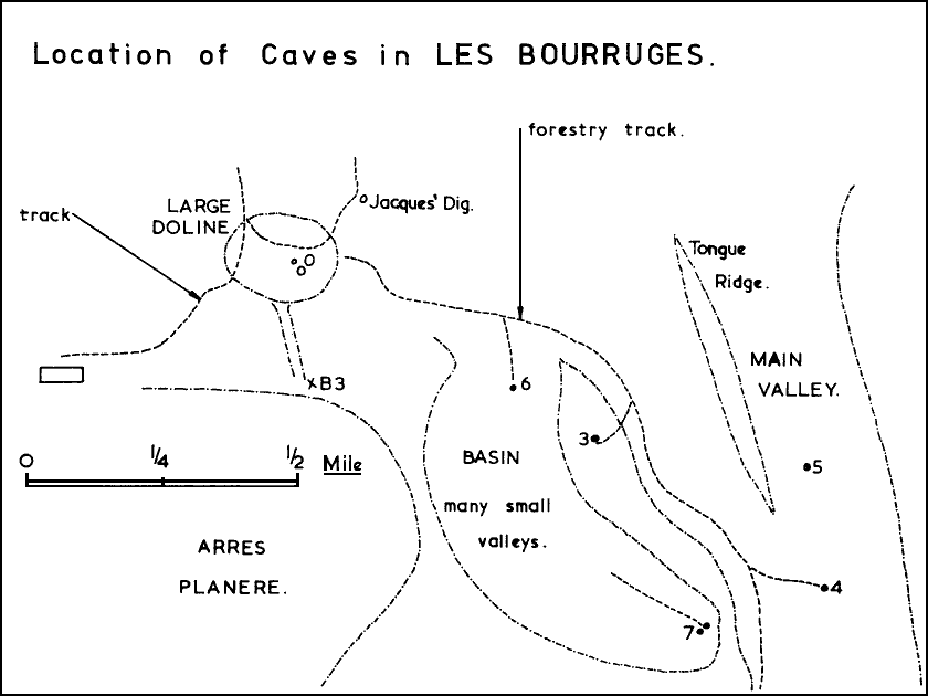
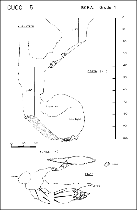
For a change, the weather was kind to us and Julian and Rob, aided and abetted by Nick and Steve at irregular intervals (they were working in Barachegagnako Harpia), managed five days of prospecting, culminating in the rediscovery of CUCC 3, that long lost gaping chasm reported in (1), which had eluded us ever since it was found in 1971. Work began on Friday 10th August when Julian and Rob set out into Les Bourruges, an area of dense scrub, limestone clints as big as houses, and many small valleys to the east of the ski station at Arrête de la Pierre Saint Martin. The intention was of finding CUCC 5 which had been discovered but left undescended at the end of the 1972 expedition, (2). The path to CUCC 4 which was painted through the forest the previous year was easily relocated, and upon arriving at 4 we met up with some members of the Spéléo Club de la Tronche who were about to commence digging at the bottom of 4. After much difficulty with the language barrier, we ascertained that they had been prospecting the area above CUCC 4 for two weeks, had found only four new pots, none of which went deeper than 100 feet, were thoroughly dejected and were "never going to come back". They had been looking for, but had failed to find CUCC 3, which was not surprising as it turned out that they had been looking in totally the wrong area. Their lack of success seems to suggest that the area above 4 is too high up for a negotiable entrance to the Rivière, which must be split into many small inlets at this early stage.
The entrance to CUCC 5 was located without too much trouble and Rob changed into caving gear whilst Julian unravelled ropes and ladders. A 20 foot pitch in the long entrance rift was descended to a steeply sloping gulley floored with rotting vegetation, mainly pine needles. The gulley descends to a depth of about 50 feet below the surface where it breaks out into a small shaft and vertical pitch of about 40 feet landing on a snow slope. This 45° slope descends for a further 20 feet of vertical distance to a hopeless choke of boulders at the bottom with a narrow draughting rift leading off. A traverse about 15 feet up the pitch soon closes in and becomes too narrow, (see sketch survey). The cave was quickly derigged as clouds had begun to gather on the surface and it had begun to thunder ominously. We returned to base and watched a rather spectacular thunderstorm from the safety (?) of the car.
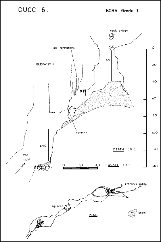
Thus having cleared up the previous year's work, we began on Saturday 11th August by setting out from the ski station to prospect the area above the forestry track and to the east of B3 (see appended sketch map), a pot discovered in Easter 1973 by the French, becoming too tight at a depth of 1100 feet, and after they had dived a 150 foot long sump at the bottom as well!!! The object of starting prospection here was to attempt to retrace Nick and Jont's steps on that misty day two years previously when they discovered CUCC 3 and then lost it again. After about 2½ hours of slogging through the dense undergrowth, Julian gave one of those shouts which means either that someone has found a pot, or has both found a pot and fallen down it as well...! The entrance was so well concealed that one could only see it from about 20 feet away, but it is nevertheless a gulley about 40 feet long and 20 feet wide with a 30 foot pitch at the bottom. Nick abseiled down the 30 foot pitch and over a dangerous snow slope to a depth of about 80 feet, where an awkward squeeze about 8" wide and 3 feet long over a large jammed boulder halted immediate progress. Poised above the squeeze, in a small aven, are several tons of ice stalactites and curtains which were slowly melting in the quite considerable draught emitted from the shaft below. It was decided that ladders would be advisable as the shaft belled out again below the constriction, and would have been difficult to reverse safely by prussiking alone. There remained only to paint a trail from the cave down to the forestry track and when this was completed we returned to Arrête for more food supplies and tackle.
At about midday on Sunday 12th August, Julian and Rob entered the pot with ladders and the squeeze was quickly passed to a broken 40 foot pitch which is extremely dangerous as its walls are coated with a layer of crystal clear ice about 2" thick. From below, the boulder appears to be supported by very little except the ice flows which are slowly melting. The bottom section of the pitch is in a very large aven and lands on a choked floor covered by the inevitable snow plug. A strong draught came from a rift about 3² wide down which stones rattled for about 20 feet vertically. An extremely dangerous traverse on ice ledges about 30 feet from the bottom leads to a wider section of the rift which shuts down after going round a narrow corner. An examination of the area on the surface above the pot revealed two small shakeholes lurking in the undergrowth which resumably correspond to the two explored avens. A further and much larger shakehole exists about twenty yards further away above a position just beyond the end of the cave. This could be the top of a large pitch in another parallel aven; the draught at the bottom could indicate something quite big, or it might just be another surface connection in the clints nearby. All in all, a very dangerous and disappointing cave (see sketch survey).
Monday 13th August saw Julian and Rob footslogging
it back up into the bracas in order to search the
basin of small valleys above and to the east of CUCC 6 (as we had
"christened" the find of the 11th).
 A long footwork session through the most awkward walking country
imaginable resulted in the discovery of a couple of pots situated alongside
each other at the head of the basin, and since they were the best excuses for
caves which we had seen all day, we decided to give them a collective
number... CUCC 7. The task of painting a path down to CUCC 6, so that we
might have some hope of finding 7 again, was difficult, as navigation always
is in the bracas. The paint ran out about ¼ mile
before CUCC 6 was regained and so we were extremely doubtful as to whether we
would be able to relocate the caves in the very difficult conditions.
A long footwork session through the most awkward walking country
imaginable resulted in the discovery of a couple of pots situated alongside
each other at the head of the basin, and since they were the best excuses for
caves which we had seen all day, we decided to give them a collective
number... CUCC 7. The task of painting a path down to CUCC 6, so that we
might have some hope of finding 7 again, was difficult, as navigation always
is in the bracas. The paint ran out about ¼ mile
before CUCC 6 was regained and so we were extremely doubtful as to whether we
would be able to relocate the caves in the very difficult conditions.
 It was not until Tuesday 21st August that we returned to the area (this
was because of pressing developments in Betzulako
Harpia, a cave we were in the process of surveying, located near
Larrau in the same area as Barachegagnako
Harpia). The intention was to descend 7 and have a last look for CUCC
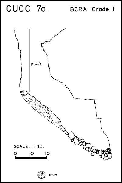
3. We had surprisingly little trouble in finding 7 and Rob descended (see
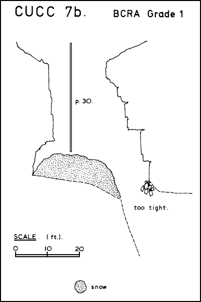
surveys). The left hand pot (7b), although shallower, is the more interesting,
as it ends in a 4" wide draughting rift down which stones fall for about 2-3
seconds before hitting what sounds like a solid choked floor. The right hand
pot is about 80 feet deep but is hopelessly choked.
It was not until Tuesday 21st August that we returned to the area (this
was because of pressing developments in Betzulako
Harpia, a cave we were in the process of surveying, located near
Larrau in the same area as Barachegagnako
Harpia). The intention was to descend 7 and have a last look for CUCC
3. We had surprisingly little trouble in finding 7 and Rob descended (see
surveys). The left hand pot (7b), although shallower, is the more interesting,
as it ends in a 4" wide draughting rift down which stones fall for about 2-3
seconds before hitting what sounds like a solid choked floor. The right hand
pot is about 80 feet deep but is hopelessly choked.
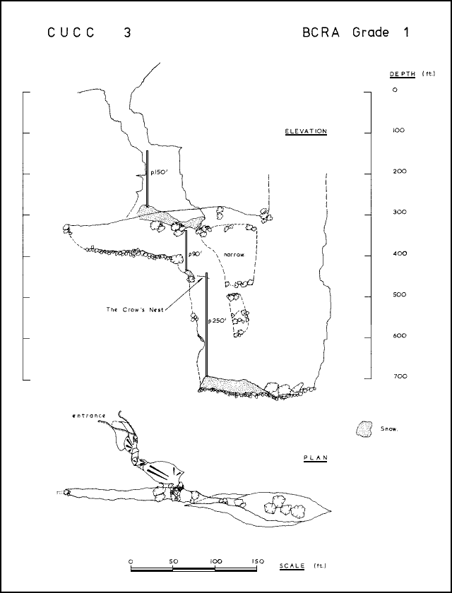
A short search of the surrounding area revealed that the forestry track and the main valley were only 50 yards distant (predictably in exactly the opposite direction to our arrows !!!), and so we decided to spend the remainder of the day prospecting the west side of the main valley below CUCC 7. After a mere one hour of work we located what turned out to be CUCC 3, only 40 yards from the forestry track! This indicates just how difficult prospection in Les Bourruges is. In the previous two years, CUCC parties looking for 3 must have walked within thirty yards of it no less than a couple of dozen times, and the entrance is a gaping rift 80 feet long and 30 feet wide !! The next four days were spent exploring and derigging this impressive piece of Pyrenean verticality.
The entrance rift is sixty feet deep to a ledge formed by a jammed dead tree, whence, via a series of greasy climbs, the head of an impressive shaft is reached at a depth of about 150 feet. This is a 150 foot pitch, much of which is free hanging, onto a snow slope which descends at an angle of 30° for a vertical distance of about 30 feet, ending at the head of a large rift in which the rest of the pot is wholly situated. A pitch of 90 feet from a ledge of jammed boulders lands on a dangerous snow cornice, and a short traverse leads out to "The Crow's Nest", a cramped two man ledge perched above a deep 4 foot wide rift. This is the top of a fine 250 foot pitch, the first 180 feet of which hang free in a steadily widening rift, to a small ledge piled with stones and ice. After a further 70 feet the bottom is reached at the head of a large snow slope in a chamber of quite impressive proportions. This snow slope descends for a further 30 feet to an area of large boulders and a massive choke in the floor. No ways leads off the final chamber which is 150 feet long and 50 feet wide. About 120 feet down the last pitch, a pendulum traverse leads to jammed boulders in a narrow section of the rift. Beyond these is a large parallel shaft. A dangerously loose traverse around this shaft reveals that the rift shuts down to nothing at the other side. It is possible to traverse into this shaft at the top of the 250 foot pitch, and stones dropped from this point fall free into the final chamber some 300 feet below. Stepping off the 90 foot pitch about halfway down, a ledge can be gained which leads to the continuation of the rift in the opposite direction. This is hopelessly choked and eventually becomes too tight and blocked. The whole pot is about 700 feet in depth (see survey). The draught which is apparent both at the top of the 90 and 250 foot pitches has mysteriously disappeared by the time one reaches the bottom, although there appear to be no ways leading off the shaft. The snow slope in the final chamber has been partially melted, and so the draught probably sifts up though the boulders and is lost in the size of the final chamber. Oh for another 300 feet of pitches at the bottom and the Rivière would have been ours !!! However, choked pots of this sort are ten a penny on the plateau, and so this find is by no means exceptional; in fact it was a disappointment for us after such promising entrance pitches.
After derigging CUCC 3, we learned from Jacques Sautereau, the president of the Spéléo Club de Rouen, that he had found a draughting but choked entrance just below the large doline where Nick had been digging in a promising looking shakehole. After about ten hours work on "Jacques' Dig", holes amongst the boulders had been revealed, down which stones dropped for some ten seconds until their rumblings could no longer be heard. On Sunday 26th August, we dug briefly at the bottom and opened a body sized hole from which a "howling gale" was blowing. Due to lack of suitable equipment, we decided that we should leave it until 1974. It was thus covered with branches in a vain attempt to keep the winter snows at bay, and we left with a firm resolve to return. A pot of this nature stands less chance of being blocked at depth and is thus very encouraging; in fact all the entrances to the big systems on the plateau are tight, and all the gaping chasms are, without exception, blocked for obvious reasons. If the Arrigoyena system follows the pattern of the Pierre, then this is clearly the correct place to start looking for a Lépineux type entrance. One hopes that the pitches aren't quite that big (1100 feet), but if they are, and they lead down to the Rivière, I for one shan't complain.
That, in brief, is our contribution in 1973 to the search for the Rivière d'Arrigoyena, and that is the position at the present time. If things go well next year, the Rivière should be discovered by some lucky club, and we hope it's us, because we have contributed more to the search so far than anyone else.
References:
(1) Cambridge Underground 1972, "In at the Deep
End", pp 40-48
(2) Cambridge Underground 1973,
"CUCC 4 and 5", pp 21-22
| CUCC Home | ||
|---|---|---|
| Previous: Betzulako Harpia |
CU 1974 Contents Page | Next: Digging in a Doline |