by P.B.Warren
It's not every day you can go for a walk, and come across a previously unknown open cave entrance. Indeed the finding of Notts Pot was regarded as unusual when it was reported thirty years ago: that someone walking on the fells could find an open cave entrance. However such was the situation I found myself in a couple of years ago when I was walking across the bleak watershed that Lanteshop cave lies on. This expanse of peaty moorland must surely be one of the remotest areas in the Three Peaks region, lying as close to the head of Littondale as it does to the valley of Ribblesdale and a long way from both!
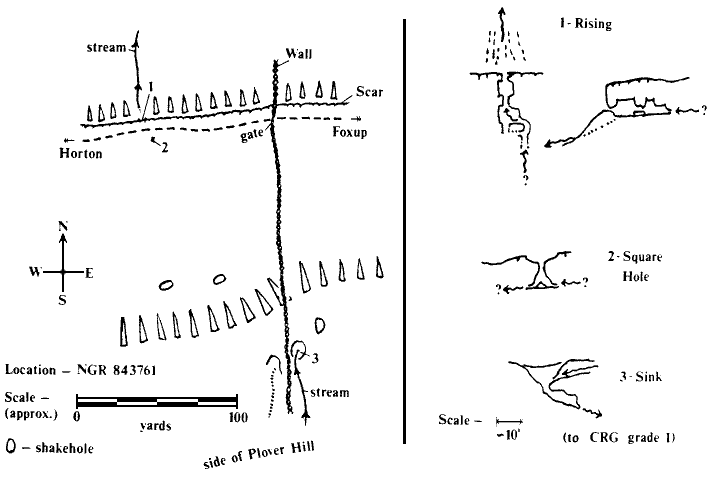
So it was, one Sunday, that my father, a friend and myself found ourselves on the edge of Plover Hill with our sights set on walking towards High Greenfield Knot. We descended the steep hillside and soon picked up a small stream rising at the bottom of the millstone grit. We followed it down to the start of a flat escarpment formed from a bed of limestone well above the Great Scar. The stream danced into a shakehole and disappeared underground between a few boulders. Nearby was another shakehole with a dried up stream bed ending in a similar manner - it obviously also took water in wet weather.
We were intrigued, but being equipped only for walking, could not attempt further exploration. We went to the edge of the escarpment where a path was met, presumably the one which goes from Horton-in-Ribblesdale to Cosh and Foxup at the head of Littondale. Another surprise - just over the edge of the escarpment, about three hundred yards from the sink, a stream reappeared from between boulders at the foot of a small slope of mossy boulders. Furthermore, at the top of this slope, we observed an inviting gap at the foot of the small scar. The noise of water could be heard! I resolved to return with a light, and made a mental note of the location. I then set off after my father and friend on the tiresome plod to High Greenfleld Knot - a trudge I can recommend to anyone who has the view that fell walking is easy!
On returning home, no mention of any caves on that side of Plover Hill was found in the guide book - had I had the privilege to come across a previously unknown, open cave entrance?
The next chapter to the story came in the late summer of 1986, when I went to the President's Invite to find that no one had turned up (miserable sods!). The thought of exploring the unknown cave had been in the back of my mind for a couple of years, and now was the opportunity to return better equipped, even though I was alone. I decided that an approach from the road that goes from Stainforth, passing behind Pen-y-ghent and down the side of Pen-y-ghent Gill to Littondale would be the best. I would be starting quite high up but would still have the shoulder of Plover Hill to cross, not to mention more bog tramping.
The clouds were forming quite high up Pen-y-ghent but still obscuring the summit - I hoped they would not descend onto my route, or I would have difficulty finding my way back to the road, let alone finding a remote cave entrance from such an unusual direction.
My luck held, and apart from being "misted up" a couple of times, I reached the sinks at the back of the escarpment without incident. Having succeeded in my navigation, I now hoped to find a couple hundred yards of virgin cave.
I went first to the dark opening above the rising, donned helmet and lit carbide. The original opening led only five feet behind the face of the scar, but on removing some stones and earth, the true entrance was revealed. Inside was a small crouching chamber which had the stream running from between a couple of blocks at the far side. A squeeze over one block led to another small chamber and on looking round the side of a large boulder, I saw the stream emerging from a low crawl, which would need a wetsuit to explore - I hadn't got one.
"Oh well," I thought, "there's still the sink." I reversed back out into daylight, and then made my way towards the sink. I passed a group of four hikers who had stopped for lunch on the footpath which ran along the top of the scar. It must have been a strange sight, a lone figure in this remote part of the Dales, carrying helmet and lighted carbide; who emerged from nowhere, crossed the beaten track at right angles and disappeared again as quickly as he had appeared!
I pulled some barbed wire and a couple of blocks from the sink, and tried to make an easier route for the stream so I wouldn't get so wet. Eventually I squeezed down and ducked my head under the side into what seemed to me to be a huge descending passage (it was actually about five feet square). My heart leapt - as anyone who has spent many hours searching in vain for new caves will realise - and I followed the pasage downwards. After ten feet the roof dropped abruptly and the stream disappeared down a five inch slot. Many and great are the disappointrnents for the budding cave explorer!
However, I still had hopes, for on the other side of the path across from the resurgence I had noticed a square hole with a metal washbasin in the bottom. I wondered who would bring a washbasin high up on to the fell just to lose it down a small hole, but anyway it was a different kind of sink from the one I had just been exploring! There was also the enticing sound of the stream to be heard again.
I dropped onto the washbasin where I found myself in another small chamber. The stream emerged from a wet crawl on one side, and disappeared down a similar crawl on the other. No luck here either, but never mind - as consolation there was a small curtain of relatively clean stal to one side.
That was enough for one day I decided, as I still had a long walk back. In all I had found two entrances which I left still going. It's possible there could be three hundred yards of "Yoredale Ratrun" to find, maybe with a few formations, and with a total height differential of about fifty feet from sink to resurgence. If anyone is keen enough to carry a wetsuit the distance to the entrance, they deserve the privilege of first exploration!
A rough map of the region is given for the record below: