Previous exploration: See NL 32:13 and NL 33:10 (Plan opposite p.8)
The diver proceeded to the airbell and noted the presence of a line leading off to the left. This was followed and found to be tied off to a boulder in the floor after 50 ft. Bearings taken using a wrist compass indicate the following. The first sump curves round to the right and by the time the airbell is reached is heading almost directly down the dale. The line leading off to the left proceeds into the hill until reaching a "wall" on the right made up of large fallen slabs whence it proceeds curling to the left and ends up heading almost up-dale. It may be, as suggested in NL 33:10 that the way on lies in a bedding cave at a lower level than this chaos of fallen slabs. A careful search is needed before substantial progress can be made.
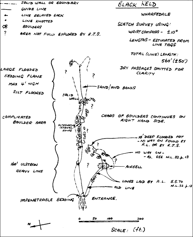
Aim: To search the left hand wall of the passage.
It was decided to lay a heavy Ulstron line, base fed, for approx. 200 ft. to facilitate a careful search of the complicated boulder areas. The diver followed a solid left hand wall for 110 ft. until boulders in the floor were met. After a further 50 ft. of progress, no ways to the left having been noticed, drag on the line became too great so the diver tied off and returned to base. Diving back along the line a 550 ft. line reel was attached and after 20 ft. or so of progress a complicated boulder area was reached. A further 100 ft. of line was then laid over and through a chaos of fallen boulders using a wrist compass as guide (magnetic bearing 100°). The way became a little easier, ie. larger, for about 50 ft. until there seemed to be no way on either to the left, or along the original bearing. The line was tied off to a flake. Length 330 ft.
Aim: (a) To belay the heavy line back, and to make sure that the
line through the boulders was secure.
(b) To attempt to find a way on from the previous limit.
Belays were added to the heavy Ulstron line at 10 and 100 ft. and this line is now firmly positioned close to the left hand wall. A further belay was added to the thin line leading off from the end of the Ulstron at a point 250 ft. from base, and a parallel line was laid from this to the left avoiding an awkward squeeze over a large boulder. The extra line rejoins the main route at 280 ft. where the route enlarges. Proceeding towards the end of the line a gap between two large boulders not seen before was noticed about 20 ft. from the tie-off point. A line reel was attached and the gap investigated and found to open out into a large bedding plane with a silt floor after a further 50 ft. or so of awkward boulders. About 150 ft. of line was laid at a magnetic bearing of 100° until the floor met the roof in a submerged cul-de-sac. A return was made after a brief search for a way on in poor visibility. Line reel left in. The 20 ft. of line to the old tie off point was coiled up and wedged under a rock on the way back. Total length approx. 530 ft.
Aim: To attempt to find a way on to the left of the previous limit.
The line reel was collected and 50 ft. of line reeled in. Proceeding to the left a ten minute search yielded only a low flooded bedding closing up after 20 ft. A flake was found and the line tied off. Line reel was removed.
Aim: To check lines, belays and stability of the route through the boulders after recent heavy flooding.
Heavy rain over the past week prevented all diving because of high water and bad visibility. This dive was made to check the route and to assess the chances of adding more line beyond the previous limit. The belays were found to have held and the bdulders had not moved appreciably, ie. the line route was still passable. It was decided that further progress from the previous limit would be impossible because the visibility was nowhere more than 18 in. and in some places absolutely zero making navigation even more confusing than usual.
Aim: To search the roof above the line beyond the boulders for a possible way on upwards which could have been missed on previous dives.
Having ascertained the impossibility of further horizontal progress because of bad visibility it was decided to look in the roof above the line already laid. The area above the first 50 ft. of line beyond the boulder area was searched but no way upwards was found. The search terminated after 10 minutes when the diver became tired of swimming into things. Visibility at best 1 ft.
Aim: To examine the airbell found by CDG divers in 1949 (CDG Report No. 2. 1949)
Visibility still being too poor to allow progress in the main continuation it was decided to explore the airbell for possible dry outlets. Expecting only a boring airbell, the diver was most surprised on climbing out of the sump to be able to explore about 100 ft. or so of crawling passage trending northwards and ending at a pot sump in a cross rift. A flat crawl continues to the right but was not pushed to a conclusion. All very muddy, presumably due to the recent flooding. Most interesting!
R.J.S.
This report is not yet available on the site.
Aim: To check the lines after the winter floods.
The visibility was very good (by Black Keld standards) and so the diver took a spotlamp along to have a good look at the passage. The line linking the small airbell with Lake 2 had broken but was not replaced as it is not really necessary, the connection being via a simple duck. All other lines O.K. The line leading on from Lake 2 at high level was relaid and a squeeze over a large boulder after 30 ft. was passed to reveal a further more awkward squeeze, which may need hand held kit to pass after only 10 ft. more. An examination of the surrounding area yielded several promising but dauntingly tight looking openings in the boulders. On the way back a quick search with the spotlight along the south side of the line through the first boulder area revealed nothing of much promise.
Previous exploration - see NL 32:13, NL 33:10, NL 37:8 (with plan), NL 38:11
R.J. Shackleton
This report is not yet available on the site.
Aim: To continue on past the limit reached in the passage from Lake I on 11.7.76.
Previous exploration: CDG Report No. 2 (1949), NL 17.10, NL 32.13, NL 33.10, NL 37.8 (with plan), NL 38.11, NL 40.15, NL 41.11.
The stal blockage which had been the limit of progress yielded after half an hour's hammering and the resulting squeeze permitted access to about 200 feet of passage ending at a low wide bedding plane after intersecting with a short section of larger passage. The end must be fairly close to Lake 2.
Aim: To complete the exploration started on 14th November.
The bedding plane became too low after a further 50 feet but a passage on the right was found to lead to a squeeze up into a higher bedding and a series of small chambers eventually connecting with Lake 2. Unfortunately no bypass to the boulder choke beyond Lake 2 could be found. It is much easier to dive to Lake 2 rather than follow the overland route which consists of some 500 feet of rather nasty crawling.
Full references to previous exploration given in NL 42:11.
Aim: to survey the passages found on 14th and 21st November 1976 and to lay new line to Lake 1.
The visibility was found to be rather poor, no doubt due to melt water of the previous week. J.T.G. dived laying new line to Lake 1. R.J.S. folowed festooned in wellies, ammo boxes etc. The survey was completed without incident save the discovery of 100 feet or so of new stuff up various little passages unnoticed on the previous trips. The old line was removed on the way out and the new one belayed back where necessary.
Aim: J.T.G. to lay new line to Lake 2 and remove the old one. J.T.G. to push the overland bedding plane connection to Lake 2 from Lake 1 and to have a look off to the right below Lake 1.
R.J.S. dived to the end of the ulstron line and attached a new reel of heavy blue line. This was laid as far as Lake 2 and belayed at strategic points. The bulk of the rather confusing maze of old thin lines was then removed. One section jammed up rather badly and will have to be cut free at a later date.
The lines are now as follows. At the entrance one ulstron line leads off. At the bottom of the entrance slope is a belay point and a blue line ("Lake 1 line") leads off following the right hand wall to Lake 1, reaching the same after a further 100 ft. The ulstron line continues near the left hand wall past a belay point after 160 ft. where two lines lead off. The red line ("cross over line") connects back to Lake 1. The blue line ("Lake 2 line") which was layed on the dive described above, leads into the boulder area and ends about 200 ft. further on at Lake 2, after passing several belay points.
J.T.G. dived to Lake 1 via the ulstron and cross-over lines, attached a search line midway along the cross-over and searched along a bearing of 100°. Difficulties with line spilling from the reel meant that a premature return to Lake 1 had to be made. In the dry passages J.T.G. then forced a lowering bedding through to Lake 2 to the left of the original route. The new route is shorter although still rather too arduous for sherping equipment.
R.J.S.
Previous exploration: C.D.G. Rev. 1964 - 65, p. 55 & 56 C.D.G. Rev. 1966 - 67, p 87 and NL 32:20 & 21.
Aim: to examine the cave in order to assess the possibilities of by-passing the difficulties of Black Keld.
Access: the farmer, Mr. J. Lambert of Mile House, Kettlewell, flatly refuses any access to this cave, as it is close to the water suppy for nearby Scargill House, a religious congress centre. The people at Scargill are equally unco-operative. The only access is by moonlighting.
The previously explored sumps were examined and previous findings confirmed. Both divers formed the opinion that, whilst this cave is clearly part of the Black Keld complex, it does not provide an easy bypass. The lengths of dry passage given in NL 32 and Northern Caves have also been somewhat overestimated. There are better chances in the main rising, if the correct way can be found.