Cambridge Underground 1983 pp 56-60
CAVES AND CAVING IN ThE SOLOMON ISLANDS
Philip Sargent
"Situated in the interior of the island.. are large limestone caverns,
known to the natives as the Suiw caves, and by them believed until recently
to have no ending.. We traversed a district of coral limestone until we had
reached an elevation of 350 feet, when we descended into a deep valley, and
followed up the bed of a large stream that emerged from a cavern of
considerable dimensions in the face of a hill of coral limestone. The
entrance to the cavern is some 60 or 70 feet in height: a fringe of large
stalactites here hangs down from the roof. A little distance within its
mouth, the cavern bifurcates into two branches of different size, through the
smaller of which the stream flows. Lighting our candles, we proceeded to
follow up the main branch, and although we had often to wade in mud up to our
knees, the novelty of the scene quite repaid us for this inconvenience. We
passed through a series of lofty hall-like chambers, in which stalactites and
stalagmites occurred in every stage, from the small rounded boss under foot
and the fringe suspended overhead to the perfect column. The whole scene was
rather weird, the flickering light of the candles displaying in turn the dark
recesses of the cavern and the dusky forms of the half dozen boys wno had
accompanied us from the village. I was much amused wnen I saw these little
imps suddenly stop and gaze with great surprise at some footprints in the
mud.. They at once began chattering together and pointing to the prints; and
I soon learned that they thought they were the footprints of one of the
murderers of Lieutenant Bower, who was still at large. However, the Bishop
soon relieved their minds by pointing out to them that they were the marks of
his leather boots during a previous visit. After we had followed this cavern
for about 500 yards we found its farther end blocked by large masses of rock.
A narrow hole, just large enough to admit the body, formed the onward
continuation of this cavern. It appeared to lead down to a steep declavity,
the bottom of which I could not see.. Near to the obstructed end, it was to
be observed that the.. stalagmites were formed at two periods, some of them
before the obstruction occurred and others afterwards..
"The smaller cavern, through which the stream flows, had been explored in
a previous visit by Bishop Selwyn, who,... by actual measurement found it to
be about 750 yards in length.. In its bed there were numerous water-worn
blocks, pebbles and gravel, formed of a dark crystalline andesite and of a
chocolate-coloured marl, of which I was unable to find the parent rocks
either in the cavern or in the valley above.
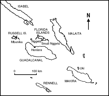
So wrote H.B.Guppy, M.B., F.G.S., Surgeon, R.N. (retired) concerning his
explorations with Bishop Selwyn on Small Nggela Island, 30km north of
Guadalcanal, in April 1882.
Caving: Geology, Geography and Anthropology
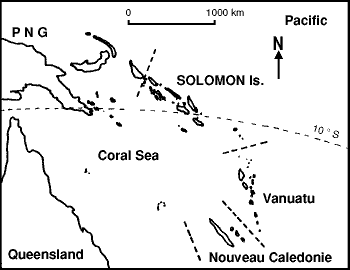 The Solomons are an arc of
volcanic islands to the east of Papua New Guinea about 9° south of the
equator. There are six large islands and many small ones; all are formed of
coral limestone overlying a core of volcanic rock. The limestone is nowhere
more than a hundred metres or so thick so there is no potential for caves as
large as those in New Guinea.
The Solomons are an arc of
volcanic islands to the east of Papua New Guinea about 9° south of the
equator. There are six large islands and many small ones; all are formed of
coral limestone overlying a core of volcanic rock. The limestone is nowhere
more than a hundred metres or so thick so there is no potential for caves as
large as those in New Guinea.
The first thing to realise about caving in the Solomons is that there are
few unexplored areas, all land and caves are owned. Caves, sinks and
shakeholes are well known parts of the landscape and the local people go down
some of them a long way: two-hour crawls have been mentioned. The second
thing to realise is that many caves are "tambu" (forbidden) and if you say
that you enjoy caving, this can be regarded as the equivalent of saying that
you go round smashing up churches for fun. Even going around asking about
caves that are not tambu won't help: they might be tambu to another group of
people. The most dangerous area in the Solomons for this sort of thing is the
West coast of the island of Malaita.
Solomon Islanders are very devout and in the villages many go to church
every day. In spite of this omnipresent Christianity, "Custom" practices are
common, nearly every village has a Custom House and Custom Caves can
sometimes be recognised from signs outside. These range from the blatant
(human skulls, pig skulls, altars..) to the subtle; bits of string tied
around branches or bits of stal, coconut halves on sticks, wall-building
etc., in fact sometimes so subtle that a European (Waetman) would have
trouble noticing them. Gail has been having a lot of trouble trying to go
caving: on one occasion she waded for three hours across a lagoon to an
obvious entrance only to find it Custom. "Apparently a woman inside would be
the equivalent sacrilege to black mass in Canterbury Cathedral".
In summary, small caves are not thought to be in any way unusual, everyone
knows where they are and they are easy to find, but, as always, access is a
problem (to put it mildly). Dr.Guppy was unable to explore Guadalcanal or any
of the larger islands because he was afraid of being eaten, but he describes
two through-trips in caves in the Florida Islands and another on Uki. Several
small caves near the capital Honiara are accessible to the public, and some
are described in "Walks around Guadalcanal". The best place for caving is
possibly the island of Rennell where there are big 'non-Custom' caves. Gail's
lab. assistant's sister hid in one of these for a week because she didn't
want to go back to her husband. Rennellese people are Polynesians whereas
most Solomon Islanders are Melanesians, possibly this is why the caves there
are not tambu. The recent "atlas" of the biggest caves in the world by Paul
Courbon mentions only two caves in the Solomons: Kolokofa Cave, which is 80m
deep, and Mbao Hole, which is 364m long (at 750 yards, Bishop Selwyn's cave
is longer than this). These are presumably the deepest and longest caves of
which he could find records but unfortunately there is no hint as to where in
the Solomons these caves may be found.
Going Underground
 Philip went out to the Solomons for a
couple of weeks holiday in January, staying with Gail who is working on a
coconut plantation at Yandina on Mbanika, one of the Russell islands. Mbanika
has no known inland caves and it is unlikely that any will be discovered: the
bush has been cleared for coconuts almost everywhere and it is only 6km by
12km. The one hill, Mohoi, is 250m high. There are some wave-formed caves
accessible only from the sea in a coral cliff at Shark Point - where the
offal is thrown every Wednesday afternoon - not a very healthy place to be.
Philip went out to the Solomons for a
couple of weeks holiday in January, staying with Gail who is working on a
coconut plantation at Yandina on Mbanika, one of the Russell islands. Mbanika
has no known inland caves and it is unlikely that any will be discovered: the
bush has been cleared for coconuts almost everywhere and it is only 6km by
12km. The one hill, Mohoi, is 250m high. There are some wave-formed caves
accessible only from the sea in a coral cliff at Shark Point - where the
offal is thrown every Wednesday afternoon - not a very healthy place to be.
Our first trip was on Guadalcanal in the underground Hospital and Command
Centre dug by the Americans during the battle for Guadalcanal in 1942-3.
These are swiftlet-infested and very unsafe-looking tunnels in a small hill
overlooking the Lungga River, between Honiara and the airfield. All the
contents had been removed long ago and the paths to the entrances were very
overgrown. Gail and I were taken there one evening at dusk by a 5 year old
boy scarcely taller than the grass. One of the tunnels goes right through the
hill and we fought our way out towards the light of the full moon, below us
lay a placid curve of the river bordered on either side by thick bush: we had
come out on a completely deserted hillside and there was not a sign of human
habitation as far as the eye could see.
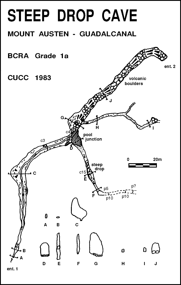
Steep Drop Cave - Guadalcanal
Wantaem tufala waetman long Inglan olketa i stap long Honiara godaon long hol
long ston long graon. Olketa pipol, long staka fren long Niu Seelan an Sri
Lanka, olketa i draev long hil (desfala hil nem blong hem Mambulu o 'Mt.
Austen') nia vilij Gegema'a. Maonden ia hem 410m hae long mbonehe ston.
Olketa save samkaen hol long hil bihaen long vilij an olketa i go wokabaot fo
lukaotem long bus.
Gail, Philip and three friends Amin, Peter and Paul drove up to a village
on Mount Austen (near map reference XK 074354 on map 9/159/8) about 30
minutes from Honiara. We were full of enthusiasm and vitality after a
pleasant morning scuba diving on a coral-encrusted wreck and we plunged into
the jungle along a winding path. It was easy walking but became very slippery
when after 5 or 10 minutes we scrambled down a muddy slope into a stream. By
now we were in dense bush with no idea where we were, but in front of us the
stream ran into a fine walking-height entrance. With Gail's stinky tied
around her sunhat with string and with Philip's wrapped in a sock we went in:
the others, not really entering into the spirit of the thing, carried
ordinary electric torches. Within five yards we were crawling in mud.
The crawl was only a couple of yards long and after it the passage assumed
the proportions of spacious parts of the Giant's crabwalk, twenty yards
further and it became a dozen feet wide with a two foot deep vadose trench.
It was easier to walk in the trench, despite the occasional jammed log,
rather than on the sloping and calcited sides. The formations looked
extremely dry with none of the wet, slick look that flowstone usually has, it
had a 'cauliflower' appearance. There were a couple of small climbs down and
then we came to a drop into a pool with a high level dry route off to the
left. It was a relief to see this because the entrance crawl would almost
certainly sump off and violent thunderstorms had been a feature of the
weather for the past few days. Beyond the pool the stream fell between jammed
boulders into a steep climb. Most of the loose boulders in the cave were
water-worn, smooth, black volcanic rock, with a few fallen limestone blocks.
There was no obvious jointing or bedding at this point, although many coral
features were clearly seen in this "Mbobnehe" limestone which dates from the
Miocene. Gail led the way down the climb and I came down last, holding my
sock-wrapped stinky in my teeth. Pete jacked because of inadequate footwear
at this point and went out. Beyond a couple of sporting climbs was a 3m pitch
but there was no possibility of climbing it, the takeoff was an overhang and
the passage widened to about 3m. Standing at the lip we could see that there
was a distinct change in the limestone at about the level of our waists. The
lower level was much denser and smoother, but was the same light-brownish
white colour. It looked as if this lower limestone had been buried under some
kilometers of overburden at some time, then reeroded and the later coral
deposited on top. At this point we can only have been about 30m below the
surface and we were only half an hour into the cave.
On the way out we tried the dry passage above the pool chamber. This
opened out with an aven to the left and small rock bridge to the right. Under
the bridge a stooping, narrow passage went on to a chamber completely filled
with very large (about 8 foot diameter) volcanic boulders. We could smell the
surface and there was some anaemic grass growing in the mud so we could
possibly have found a way through and out, but we didn't. The main passage
continued rising rapidly with a boulder floor until we came to a ten foot
diameter entrance opening into virgin jungle. There was no path to be seen
anywhere, but trusting our sense of direction, we found the path without any
difficulty, much to our surprise. We found Pete back at the land-rover in the
village with pile of drinking coconuts he had bought from a small boy, for
which we were very grateful.
The name "Steep Drop Cave" given here is temporary. The cave is
undoubtedly well-known but in our short time there we could not discover its
local-language name. Gail has since heard that a friend of a friend by the
name of Justin had been down the cave with improvised equipment and had
descended two short pitches before turning back at a hole "hundreds of feet
deep". So if anyone is in the West Pacific, there is an open opportunity just
begging to be pushed, just twenty five minutes from the international
airstrip.
The most surprising thing about the cave, apart from the unusual rock and
volcanic boulders, was the absence of wildlife. There were no bats or
beetles, spiders or centipedes. Possibly this was because the Solomons does
not have a rich cave ecology. It is generally found that diversity of species
in all habitats decreases as one travels east from South East Asia into the
Pacific, and the rapid erosion and small size of the Solomons caves must also
mean that there is little continuity in cave habitats.
Nao taem olketa i swimim olketa seleva finis long flat blong Paul olketa i
go long Saenataon fo dringim plande bia an kaikaim staka Fist Taem Raes.
Waupa
And now a final word from Dr.Guppy about his curious experiences on Uki,
near Makira Island, 100km south east of Guadalcanal:
"The Waupa Caves are hollowed out in the mass of this ancient headland of
coral limestone, which now lies some 400 yards inland. When I visited this
locality with Mr. Howard in July, 1882, we were obliged before entering to
drive out a large number of the bats by which the caves were tenanted. We
first found ourselves in an irregular chamber from 25 to 30 feet across..
Passing under a low arch, we entered a larger circular chamber.. Turning to
the right we descended a narrow, dark passage, bearing small stalagmites on
its sides, that brought us to a small chamber.. Whilst we were ascending the
narrow passage, the large bats extinguished my candle, knocked the matches
out of my hand, and generally made themselves unpleasant. Columnar
stalactites are not to be found in these caverns, which is probably owing to
the frequent detachment of large blocks of rock from the sides and roofs
through the agency of the earthquake shocks often experienced in this
island.. Other caves of much smaller size occur in different parts of the
island. Some, from which streams issue, exist close to the village of Suenna;
but I had to crouch in order to enter them. The natives allege that they can
be followed for a considerable distance."
References:
"The Solomon Islands and their Natives" H.B.Guppy, Swan,
Sonnenschein, Lowrey & Co,, London (1887). (UL code NA.2.9).
"The Solomon Islands: Their Geology, General Features, and Suitability
for Colonisation" H.B.Guppy, Swan, Sonnenschein, Lowrey & Co., London
(1887). (UL code NA.2.10)
Maps from "The Dept. of Lands and Surveys", Honiara - complete sets are
available in the University Library.
"Atlas des Grandes Gouffres du Monde" Paul Courbon,
Editions Jeanne Laffitte, Marseille (1979).
"Walks Around Guadalcanal" Honiara Tourist Centre, Mendana Avenue,
Honiara (1981).
 Index to Cambridge Underground
Table of Contents for Cambridge Underground 1983
Back to CUCC top page