Greece as a venue for a summer expedition was first discussed on Cambridge University Caving Club's return from Austria in 1980. Julian Griffiths fancied the idea of sea, sun and sand, and finding Rob Shackleton not averse to the idea, the nucleus of an expedition was formed. As it turned out, this nucleus represented the full expedition complement; so the beginning of July 1981 saw the expedition Cortina heading south packed full of diving gear.
The only firm thing we had in our minds before we went out was that we wanted to go diving rather than normal caving. Beyond that we had no clear idea of what to expect. Neither of us had been diving abroad before (except Ireland) and there is very little written in English about caves in Greece, except for innumerable articles on the Pindos Mountains. As we did not intend to visit the Pindos, this was not much help. We decided that it would be best to try and take in as many areas as possible, stopping only when there was something of particular interest or potential. That way, if we wished to return, we would have first hand knowledge of a number of areas, making it easier to make a choice of an area to concentrate on. In the event this worked very well. We saw a lot of Greece in the two weeks we were there, though we spent at least half of that time in the Mani. The Greek cavers we teamed up with there were very helpful in this respect. One had done a considerable amount of cave diving, not only in Greece but also in Italy and Yugoslavia, and was able to guide us towards promising diving sites.
Some of the sites are only accessible by dirt tracks and hence a vehicle with some off-road capacity is essential. We were quite happy to abandon the Cortina in Athens and we spent most of the time travelling around in a Volkswagen van which was more suited for these purposes.
We did not take a compressor with us, something which with hindsight we should have done. Diving shops with compressors are few and far between, Athens and Patras being the only ones we heard of. This leaves one trying to beg the use of a privately owned compressor; difficult unless one has contacts. One can rule out hiring a compressor as the hire rates make this prohibitively expensive - we were quoted twenty pounds per day.
What we saw of the Greek caves was sufficient to encourage us to return. In diving terms there is little in this country to match the old, submerged phreatic systems of the Mani and the potential of the rising at Kephalari is phenomenal.
Our visit to Greece in July 1981 was largely speculative in that we had few specific sites to examine. The results described below outline the observations we made in the areas we visited and attempt to give some idea of the potential for cave diving that exists in Greece. The country is composed almost entirely of limestone and so we could obviously visit only a small proportion of the areas, but what we did see was sufficient to convince us that many exciting discoveries are awaiting explorers and cave divers will play a crucial role in future explorations.
The Greek Speleological Society is the focus of caving activity and many cave explorations have been recorded in their archives. Anyone wishing to cave in Greece is strongly advised to contact the GSS before going, as this may save a great deal of time which would otherwise be wasted, particularly with regard to cave location.
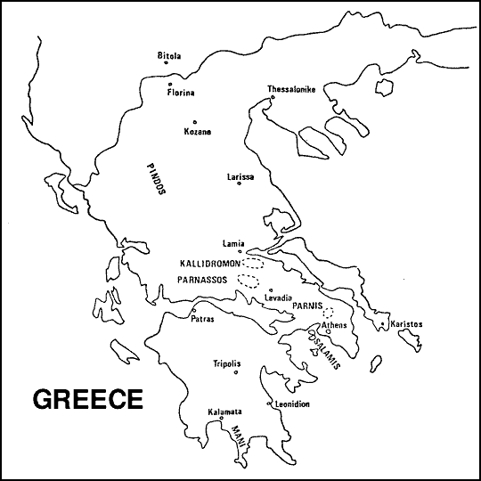
The explorations made during our visit are divided quite neatly into areas north and south of Athens, which was the base for operations. The area to the south of Athens is divided from the rest bf the mainland by the Gulf of Corinth and is known as the Peloponnesos. To the north of Athens lies the bulk of the mainland, but our activities centred mainly on the regions within striking distance of the capital.
On our journey down to Greece we decided to travel through the mountainous regions of the north rather than via the coast road. Accordingly we drove south from Bitola in Yugoslavia through Kozani in northern Greece to join the coast road at Lansa and on our way made occasional stops to look around. The area is composed of thinly bedded limestone cut occasionally by dry gorges which presumably carry flood water. No surface drainage was apparent and the area may well hold caves although the rock is not of a very consistent quality. The area lacks the altitude and depth of limestone of the Pindos range which lies to the west, and these factors combined with the poor quality of the rock make it doubtful whether the same potential for fine cave systems exists in the Kozani area. Other regions of Greece offer more obvious rewards so it may be some years before the area is adequately assessed.
a. Voulegmene (Mount Hymetus)
Along the coast to the south east of Athens beyond the suburb of Glyphada is the large resurgence in the sea at Voulegmene. The coast road lies on the cliff top at this point and inland of the road is a large collapse floored by a lake of fresh water which is used as a bathing area. The water which supplies this lake comes from the Mount Hymetus area where several potholes have been explored by the GSS. One of these potholes reaches sea level at a sump and the presence of brackish water indicates a connection with the Voulegmene Lake several kilometres distant. It is evident that a large phreas awaits discovery behind the lake.
Both the rising in the sea and the lake have been dived. The tranquil lake surface conceals a deep rift which has been dived, reputedly to -60m, to reveal a complex of phreatic tunnels. In the sea a similar complex of passages has been explored leading inland. b. North West of Athens
The city of Athens is surrounded by three groups of mountains. Mount Hymetus lies to the south east, Mount Pendelikon to the north east and Mount Parnis to the north. The latter is composed of promising looking limestone and we spent a day investigating it more closely. A feature of the area is the deeply cut gorges which presumably carry flood or melt water but remain dry during normal weather. We explored one such gorge near Fili, following upstream until we were stopped by a 3m climb above a deep plunge pool infested by frogs. At this point the walls of the gorge were over lOOm high, with the dry river bed at the bottom some Sm wide, making it an impressive spectacle, Unfortunately all we found in the way of caves was two small rock shelters which looked promising from the road but led nowhere. Several other holes can be seen from the road but we did not have time to look at them as they were quite a long way away over hostile looking ground. These open caves have presumably been investigated by the GSS but what we did establish was that the area has no sizeable springs which makes it of litle interest to the cave diver. It would seem that the percolation drainage resurges in the sea, probably in the region of Salamis.
This area is located south of Lamia on the north coast of the Attica peninsula. We travelled through the area and it is composed of good, solid limestone unlike the central northern areas of the Greek mainland.
Just south of Lamia near the historic site of Thermopylai, a deeply cut rock gorge was followed back into the mountains. This contained a fast flowing stream of considerable proportions considering that there had been no rain for some months and all the other stream beds in the area were dry. Due to lack of sufficient time a conclusion was not reached, but the cold temperature of the water indicates that it must come from a cave or spring which may have potential for exploration. This possibility should be further investigated.
There are a number of risings around Delphi which is to the south of Mount Parnassos but these were not visited. We did visit a large spring at Lebadeia which forms the source of drinking water for the town. The rising lies beneath a cafe and has been gated which makes exploration impossible. It is noteworthy however that the rising carries a large flow and this augurs well for the potential of the area. An examination of the other springs in the area with a view to diving could yield interesting results. The geomorphology of this area has been discussed by previous investigators. (Sweeting, M.)
Although an island, Evia has high mountain ranges sloping steeply to the sea, and like most of the rest of Greece appears to be solid limestone. According to the Greek cavers the best area is to the south where large fresh water springs have been discovered in the sea. We wanted to visit an area to the south east of Evia, along the coast of which Giorgos told us that he had found some promising looking springs. Unfortunately the route to the area involves 30km of rough tracks which would have proved difficult for our vehicles. It is possible to get a boat from the town of Karistos but the "service" is infrequent, especially the return, and so we decided not to risk getting stranded. A Land-Rover could reach the area but a boat may be necessary even then for the transportation of diving equipment along the coast to the actual sites.
To the north of Kimi, a seaside resort on the east coast of Evia, is a large range of mountains. We drove across these on dirt roads to reach a small village on the coast where we spent two days. Sea caves are quite common but we only found one fresh water spring. This was explored by free diving but appeared to be hopelessly choked.
The highlight of our stay on Evia was without doubt a visit to Agia Trias. This cave lies above the town of Karistos at the southern tip of the island. A stream emerges from a capped rising, but a small cave nearby yields a 10m climb down into the water a short distance inside. Within 50m of the entrance are a church and a taverna which, as JTG pointed out, gives the diver a choice of his method of calming his pre-dive nerves! The cave is almost British in that for all its all too short 500m length it comprises a lively and sporting streamway. The difference is that the water is warm. At the end of the open stream passage, which is developed entirely along the strike, is a large, rather silty sump pool. JTG kitted up whilst RJS, Giorgos and a German girl Andrea, who had acompanied us on the trip took photographs of him. The sump proved to be only 30m long with a maximum depth of 3m and although low in places it is easy with 1274 litres of air. JTG surfaced in a large continuation of the streamway, and after dekitting explored 150m of passage to a sizeable chamber where the stream cascaded in from an opening 10m up. The explorer climbed to within 2m of the top but the last bit was tricky and so, having noted that the passage at the top appeared to be wide open, a return was made. The journey out was punctuated by stops for photographs with RJS being persuaded to stand beneath waterfalls and in pools neck deep for the benefit of the cameras.
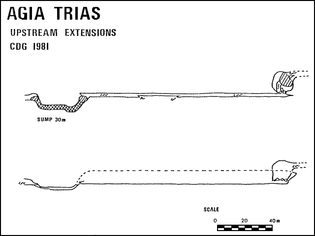
The lack of surface drainage in the mountains above Karistos suggests that a sizeable percolation network may lie beyond the climb. During the trip into the cave however, twigs were found above one of the plunge pools. Since they were found above normal water level it is probable that winter flood water brought them down. This find, coupled with coarse sand not normally found in percolation caves suggests that the system may be fed by flood sink holes which may provide upper entrances.
During our stay in Greece we spent a week in the areas to the south of Athens, most of this time being devoted to the caves of the Mani peninsula in the extreme south. The Peloponnesos holds great caving potential throughout its area and on our journey back from the south we visited the region around Tripolis where an extensive drainage system has been shown to exist.
This area is located immediately to the south east of the town of Kalamata in the southern Peloponnesos, and amongst its fine caves is the famous show cave of Pyrgos Dyros. The caves in this area are all very old phreatic tunnels which collect water by percolation and resurge in the sea. It is evident that they were formed before the last ice age, and during the ice age when the level of the Mediterranean was some 100m lower than it is today, the passages were abandoned allowing the formation of spectacular calcite deposits. The post glacial rise in the sea level has re-flooded many of the tunnels and the abundance of calcite formations is a feature of the submerged routes.
The best method for finding cave entrances in this area is to search the coastline for fresh water springs which are easily noticeable as patches of cold water in the warm sea. Also the area in which the fresh water mixes with the salt water is characterised by an opaque quality caused by the differing refractive indices of the two mixing fluids. Occasionally these springs have associated dry caves in the cliffs above, which allow access to the phreatic tunnels inside. Searching the mountains set back from the coast for potholes would seem to be a futile exercise since there is no surface drainage and any potholes which might exist would almost always be choked. The region is also very hostile to the explorer being very hot and thickly clad in low thorny bushes which make walking a slow and painful process.
At Pyrgos Dyros the rise in the sea has flooded the cave to within a few feet of the roof and the tourists are guided round in punts which are propelled by pushing on the roof! We visited the show cave, which is a must for anyone spending any time in the area , and were amazed at the profusion of the stalactites. It certainly gave us the idea of the potential of the area and fired our enthusiasm for exploration. Unfortunately diving is permitted only by special arrangement since archeological remains have been found in the cave. Another site along the coast has been dived by Greek and Italian divers in a large passage to a complex boulder choke which corresponds with a similar feature in a cave inland. It is very likely that there will be other caves to be found in the area which will follow a similar pattern of development, although it is unlikely that the level of the sea will give a repeat of the amazing situation at Dyros. During our visit we explored two cave systems both of which resurge in the sea.
(a). Cave of Selinitsa.
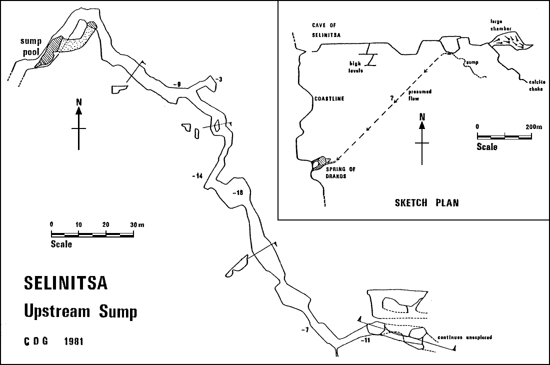
This is an extensive cave system situated on the west coast of the peninsula just south of the small seaside town of Selinitsa. There are in fact three caves in close proximity to each other. Firstly, a large fresh water spring in the sea called the Spring of Dracos (spring of the dragon), secondly, a small cave with several entrances the most accessible of which is close to sea level, and lastly the main entrance to the cave of Selinitsa which lies some 10m above sea level overlooking a nudist bathing area which makes for very interesting scenery whilst lurking out of site in the entrance.
The Spring of Dracos was reached by a swim along the coastline in full kit which was quite a bizarre experience. The rising is noticeable by the quantities of cold water issuing, and beneath an impressive cliff are two large entrances below water level. RJS dived first using 1274 l and 425 l whilst JTG sat waiting with Giorgos on a rather surf-swept ledge. The line was belayed at a depth of 10m and RJS explored the left hand entrance which was an impressive 5m by 8m arch . After only 15m a lake chamber was entered and the diver could look back through the two entrances into the sea beyond. Above water the chamber was 10m high and the water was about 8m deep with one small area where one could stand chest deep and look about. Beyond the lake which is some 25m in diameter the large passage was followed at 6m depth for 20m to a narrow rift partially blocked with calcite. Unable to see anything more attractive the diver belayed the line and returned. JTG and RJS then dived back to the lake together and JTG examined the rift. The main source of fresh water was found to be a small passage to the right which was of small dimensions with a strong current and was explored for a few metres before a return was deemed prudent. One could also surface in a very small airbell at the top of the rift where water entered down a calcite slope . After a few minutes the eyes became accustomed to the dark and the whole cave can be explored without the need for artificial lights. The total length is 60m and from the extreme limit a clear view out of the entrance is possible. JTG climbed out of the water in the lake chamber but no dry continuation could be found. Difficulty was experienced in kitting up again out of depth in the surging water of the main chamber.
The main Cave of Selinitsa contains some 11km of large phreatic tunnels including an enormous chamber floored by breakdown. The cave has been explored and surveyed by the GSS, although it is clear that much remains to be found here. The cave is well decorated but unfortunately vandals have plundered and spoilt many of the beautiful crystal deposits. After 1km of easy walking passage a network of smaller passages is reached and it is here that a short ladder pitch drops into a large and inviting sump pool with water that is slightly brackish indicating a connection with the sea. RJS dived this heading in an upstream direction indicated by the small visible movement of water. A line was already in position and this was followed until it ended after 50m. The passage up to that point is a large tunnel about 5m wide and 3m high with small patches of silt on the floor. An ascent can be made after 20m to a small lake chamber which JTG reached via an alternative overland route. For divers however, it is easier to start at the bottom of the pitch rather than drag the gear to the second sump pool. From the end of the previous dive RJS laid 55m of new line in an easy passage gradually deepening to 12m with visibility at least 20m, ie. as far as aquaflash torches could penetrate. At several points there were underwater stalactites and stalagmites which came as quite a surprise and gave the diver a rather eerie feeling. At the end a large flooded chamber was reached and the depth appeared to shelve off steeply. Mindful of his third margin, since he was only using 1274 l and 425 l the diver was obliged to return.
Several days later JTG, eager to see for himself the delights of the sump that RJS had been going on about so rapturously, got his chance for a dive. Wearing twin 1274 ls he laid 75m of line beyond the entry to the flooded chamber reaching a maximum depth of 17m and ending at 8m depth with the continuation large and inviting. The formations in this section are rather good including a calcite cascade dotted with stalagmites at 15m depth. Diving immediately on JTG's return RJS made a further 20m of progress to a deep flooded pot, the bottom of which could not be seen. Descending slowly, a large gallery was noted leading off at 12m depth. This seemed a more attractive prospect than the depths below and so it was followed for 10m to a junction with two continuations leading downwards. This time the bottom could be seen below and the diver estimated this to be a depth of 20m. Already overweight at 15m and having difficulty with the twin 1557 ls RJS decided to return at this point and so the line was belayed at the junction. Total length 210m and the prospect of much more to come!
Having arrived back at base with air to spare RJS examined the downstream continuation to retrieve a cylinder boot lost on the earlier trip. The passage was found to be of similar dimensions to the upstream passage, and shelved off to 10m depth in a silt floored tube. The line was tied off after a further 15m and the wayward boot was recovered. According to the GSS survey the sump pool lies 700m from its assumed rising at the Spring of Dracos, and the prospect of diving from here out into the sea is quite exciting, although it would appear to involve some small passage in the vicinity of the resurgence as the discoveries detailed above have shown.
The small cave with several entrances was examined via the low entrance near sea level and was found to contain an interesting freedive out into the sea. The obvious continuation quickly chokes; it is probably associated with the main cave above and would appear to have little promise.
(b). Stradiotis Cave
This cave is situated some 30m above sea level on the eastern coast of the Mani peninsula close to the small village of Floiuchori. Our interest was in the diving potential of a rising in the sea below the cave. Giorgos chatted up a local fisherman who kindly consented to take us to the rising in his boat. JTG leapt over the side with mask, fins and snorkel, and examined the rising which was found to be a slot at 3m depth with strong current emerging. The rising was diveable but of small dimensions so we decided to examine the main cave in the hope that the river could be gained from inside as at Selinitsa. Searching back along the coastline to Floiuchori, JTG free dived through to a large lake at the entrance to what seemed to be a cave. At the far end a dry passage could be seen but without a light could not be entered. This may be associated with a hole in the cliffs above which we came across on a walk over to the main Stradiotis Cave.
The dry cave was found to be infested with spiders and bats and having spent the best part of an hour slithering about in the detritus we decided there was no negotiable way on. Lacking adequate supplies of air we decided to use our limited reserves on other sites. Any future divers in the area should note that it is desirable to use a boat to reach the rising as the coastline at this point is clad with thickly packed thorny bushes which make walking unpleasant. They should also note that the dirt track stops about 1km short of Floiuchori. The rest is walking through olive groves.
On our way back to Athens after our visit to the Mani peninsula we visited a resurgence at the village of Kephalari located south east of Tripolis which is in central Peloponnesos. The spring is associated with a large rising in the sea at the town of Leonidion on the east coast of Poloponnesos in the Gulf of Argos. Sinks in the mountains behind Tripolis over 30km away have been dye tested by the GSS and shown to emerge at Kephalari and later at Leonidion. The rising in the sea is so powerful that the Greeks have built a sea wall round it and run fresh water back inland to irrigate their fields. Prior to this construction the rising was explored by Italian and Greek divers for only a short distance, the entrance being at a depth of 30m and the passage continuing open beyond the limit of exploration at -40m. The spring at Kelphalari is itself a very powerful rising and even in the height of summer looks to carry about double the flow of Brants Gill in Ribbleshead. The source of the water is beneath the foundations of a church and has been dived for 100m or thereabouts to emerge in a large submerged passage after passing beneath the crypt amongst some very dangerous poised stonework. When we visited the spring the water was distinctly cloudy and we did not dive because of lack of adequate air supplies. The rising is easy to reach by road and the enormous potential of the site which has been demonstrated by the dye tests makes this site an excellent diving prospect. As with all good Greek caves there is a taverna within 100m of the diving site.
Both divers used conventional wetsuits and found these to be adequate, in fact the temperature of the water was such that no neoprene gloves were worn. The air temperature in the caves was also high and where a carry of some distance to the sump was involved it was more comfortable to change into wetsuits at the sump, swimming trunks and a tee-shirt sufficing for the rest of the cave.
Underwater the main problem was one of buoyancy. The use of large tanks over long distances necessitates neutral buoyancy at all depths. If this is not attained too much effort and air is expended in moving along the passage and the visibility can easily be ruined by contact with either the ceiling or the floor. The best method of achieving this would appear to be by means of a life jacket, such as the Fenzy, or a special buoyancy bag strapped to the chest such as the American cave divers use. The use of such a jacket is also invaluable when the dive starts in the sea. Swimming to such dives can be very tiring and incorrect weighting only aggravates this problem.
Visibility might have been thought to be the least of problems in such sumps. However because it was so good it was worth trying to preserve it and one can understand why the Americans go to such great lengths to avoid stirring up silt. Correct weighting facilitates this, but some things are unavoidable. In the cave of Selinitsa there was a layer of silt on the ceiling which was easily disturbed by one's air bubbles and descended like a muddy snow shower.
4mm orange sinking line was used, 150m being the maximum reeled onto a line reel at one time. Because the sumps are so easy (in terms of size and visibility) there is a great temptation to go what might be considered too far and it is possible that this is an important factor underlying accidents in such sumps, though no study has been made of this. Certainly 150m seems a safe limit to the amount of passage that can be explored while retaining a good knowledge of the route for the return journey. Naturally this limit will depend critically on the diver and the nature of the sump. One useful idea gleaned from the length of line that had been laid in the Cave of Selinitsa was the use of loops of elastic or inner tube to attach the line to boulders and does not entail the extra weight (and expense) involved when lead weights are used to position the line.
Whilst talking to a Greek cave diver he expressed his concern that we did not dive in pairs. The English method of training seems to emphasise the self reliance of a diver and indeed in a lot of sumps in the UK, diving in pairs is just not practical. In larger sumps diving in pairs is only of use if one can actually help the other in difficulties. If the latter is encountering problems with his air supply this can normally only be done if one is using an extended low pressure hose, at least with any comfort. Another possibility is that it may be possible to help a diver ensnared in the line. To weigh up against these though is that one may just not have the air reserves to help the other diver and, depending on the reaction of the other diver, this can be extremely dangerous. Also a diver entangled in the line may be forced to cut the line with another diver further into the sump. If the visibility has been stirred up as well this can result in serious problems for the second divet. In the event the divers stuck to what they were used to, that is diving independently.
Finally a word on back mounted cylinders. There seems to be no justification for using these rather than side mounted cylinders even in the largest sumps. It is possible to carry as much air round one's waist as on one's back, though it has to be admitted that there are times when both have to be used. The main disadvantage of back mounted cylinders is that their valves are very exposed and it is often not possible to reach them to turn them off. Trying to regulate the flow of air from the back mounted cylinders by turning it on and off (for whatever reason) is extremely difficult. The only minor problem with side mounted cylinders would seem to be the backache experienced when carrying many cylinders.
In conclusion cave divers in the UK seem to take pride in the fact that they do things differently because their sumps are different. However, the sumps are not always so different and in many respects they have a lot to learn from their fellow divers abroad, but also many of the techniques used could be usefully adopted for use in the UK. Likewise we do not think that foreign divers always get it right.
Although we were not able to visit many of the promising regions, what we saw of Greece was sufficient to convince us that there is a great deal of potential for new cave exploration.
Moreover, the development of the cave systems is such that diving may be the only way to gain access to the percolation systems which must lie behind the coastline resurgences. We feel sufficiently enthusiastic about the possibilities to plan a return to the sites we visited in 1931 to explore further. The following would be a provisional list of specific aims for 1982:
The main limitations encountered on our 1981 expedition were lack of sufficient time and shortage of air. The reason for the lack of time was that we had to look at as many sites as we could in the time available to us and so we were not able to stay at any one site. Now that we have specific projects to pursue we should be able to plan our time more precisely. With regard to the problem of air, it will be necessary to take a portable compressor with us in 1982. The only filling stations are in Athens and in Patras, which are so far from the areas of interest as to rule out the possibility of using them on a regular basis. It is not practical to carry a sufficient number of charged cylinders to enable a sustained exploration at a remote site to be carried out. There is also the safety factor. During our visit in 1981 we were always careful to allow adequate backup of equipment and air should a diver get into difficulties. For a more concerted exploration effort probably involving more divers, local filling facilities will be essential.
In conclusion it can be said that our initial expedition to Greece has confirmed our belief that the country holds good potential for cave diving, and it is well worth a more serious and carefully planned exploration effort. The 1981 trip has laid the basis for further work at several sites, and we have developed useful contacts within the Greek Speleological Society. We are confident that a return visit in 1982 can build on this foundation and further add to our knowledge of cave development in this important and interesting area.
There are certain rules and regulations governing caving in Greece, primarily designed to protect the country's archaeological and natural heritage. Generally the authorities take a reasonably relaxed attitude to their enforcement, but if there is any doubt regarding the sites being visited the Greek Speleological Society (GSS) should be contacted with a view to obtaining the necessary clearances. In any event it may be better contacting the GSS outlining the areas one wishes to visit and the aims of the expedition in order to identify the potential problems before one gets there.
The GSS acts as the governing body for caving in Greece. It carries out a program of collaborations with foreign clubs, but this does not prevent foreign clubs organising their own expeditions. Out of courtesy, and to avoid duplication of work, the GSS should be informed of any finds. The GSS meets on Wednesday evenings in Athens and their address is as follows:
ELLINIKI SPILAILOGIKI ETAIRIA
MANTZAROU II
ATHENS
GREECE
Official looking notepaper helps when corresponding with them. Many of them speak fluent English so inability to write in Greek is no handicap.
We would like to thank Nikos Tsimsilis, Giorgos Abagianos, the "other" Nikos and all the members of the Greek Speleological Society, for the help they offered us in locating and diving suitable sites, and for the hectic social life they arranged! We would also like to thank Nick and Sally Reckert, and Katriona and Taki Synotis for the hospitality they provided in Athens and the help they gave us in organising the expedition.
Julian Griffiths