
| CUCC Home | ||
|---|---|---|
| Previous: CUCC v The Grand Circle |
CU 1973 Contents Page | Next: A Major Discovery |
I am not a geologist, nor am I an expert on the Black Keld system. However, a quick glance at the bibliography at the end of this article will show that there is only one club which knows the system anyway, so I am no worse qualified to write on the subject than the vast majority of potholers in Craven. Similar opinions to mine may already have been published - quite frankly I just don't know - but I hope that at any rate the article will demonstrate what a layman can do with a little first-hand knowledge of an area and a small collection of books and maps. At least the article might provide food for thought.
Figure 1 is a sketch-plan of the system as it is known at present. When one studies the surveys of Langcliffe and Mossdale, it becomes apparent that most of their passages trend in the same direction; that is to say, along a line running approximately NW/SE. In the case of Mossdale, in particular, it will be seen that the passages have formed along several such lines in parallel. It seems logical, therefore, to assume that cave development in the area is controlled by a complex of local lines of weakness running along this particular orientation. Dowber Gill passage is a case in point.
Bearing this grid in mind, another important series of lines of weakness seems to be indicated about 3,000' South-west of Langcliffe and Mossdale, by a series of sinks marked 2 to 9 on the map. These hypothetical lines are drawn in.
The second most common orientation of passages in the two major systems is approximately E/W varying to ENE/WSW. This is also testified by the nick in the scars directly above Black Keld itself, and by New Fearnought inlet at the bottom of Langcliffe, which, although tests have proved inconclusive, appears to come from Swarthgill Pot (1).
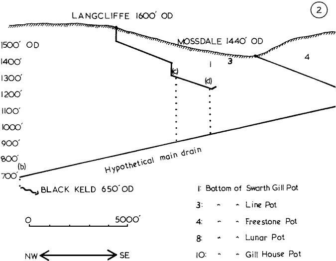
Figure 2 is a sketch section of the system, and assumes the existence of a Main Drain flowing along the postulated lines of weakness. The straight-line gradient of Langcliffe is about 1:16; that of Mossdale about 1:24. Let us assume - to be pessimistic - that from Stream End Cave in Mossdale the water flows directly to the Main Drain. Since, in doing so, it will be heading across the dip - slightly up-dip, in fact - we may suppose that the gradient will become even shallower, say 1:30. The distance to the Main Drain being 3,000', we now have an altitude for the Main Drain at the Mossdale Inlet of 100' below Stream End Cave. This position is marked (a) on the section.
We have no way of gauging the gradient of the passage from the downstream end of this hypothetical Main Drain to Black Keld, but let us call the drop 50'. This is marked (b) on the section.
With these two points plotted we can now draw in the line of the Main Drain itself and make a few conclusions. The first of these is that it seems improbable that Mossdale will go much deeper. Even if it continues along its present line beyond Stream End Cave it will have to turn westward sooner or later and as soon as it does so its gradient will drop and the passages will become even more waterlogged than they are already. Moreover, the up-dip nature of the streamway will encourage sluggish, paraphreatic flow, with its attendant sumps and mudbanks. All this assumes, of course, that the Stream End Cave water does not flow to Low Mill.
Langcliffe could go a lot deeper. Poseidon Sump (c) is a very constricted and backs up at least 40' in flood, so the chances of passing it are not good. If it is passed, however, there will be a drop to the Main Drain of 400', giving a gradient of about 1:8; this could be accounted for by a series of wet climbs and pitches, something lacking from the area at present.
The drop from Dementor Sump (d) would be in the region of 260', giving a gradient of about 1:12. This may not sound so promising, but in fact it is steeper than the straight-line gradient of the rest of Langcliffe. Also, Dementor shows no sign of backing up and a preliminary dive has shown the underwater passage to be large and open, so it may go yet.
As to the Main Drain... Its gradient is shown to be about 1:38; that's a lot shallower even than Mossdale. However, there is no reason why it should not be passable, if only in short stretches. In the first place it is probably a lot older than Langcliffe or Mossdale, which means that it will have had a greater opportunity for downcutting. Couple this with the possibility that it has formed along a really important line of weakness, and one may be left with a deep canyon-type passage, rather like Dowber Gill.
Finally, if access is never gained from Langcliffe, or Mossdale or Black Keld, it may be possible to find a way in from the surface. The lowest points of the most interesting pots are indicated on the section. Line Pot is distinguished by having an impressively wide pitch, Gill House Pot by the position of its lowest passage, although it is displaced a long way horizontally from the Main Drain. Unfortunately these pots are all old and full of loose rubble. You never know, though....
There, then, are a few thoughts on the Black Keld system. They may be total rubbish, they may not. Anyway, I'm just off to the library to discover the Penyghent Master Cave.
Bibliography:
LUUSS (ULSA) Newsletter No. 3, 1965
LUUSS Newsletter No. 4, 1965
ULSA Review No. 5
ULSA Review No. 8
ULSA Review No. 10
Descent No. 22
| CUCC Home | ||
|---|---|---|
| Previous: CUCC v The Grand Circle |
CU 1973 Contents Page | Next: A Major Discovery |