| CUCC Home | ||
|---|---|---|
| Previous: So you think you're hard, eh? |
CU 1971 Contents Page | Next: Rear End Paper Photo |
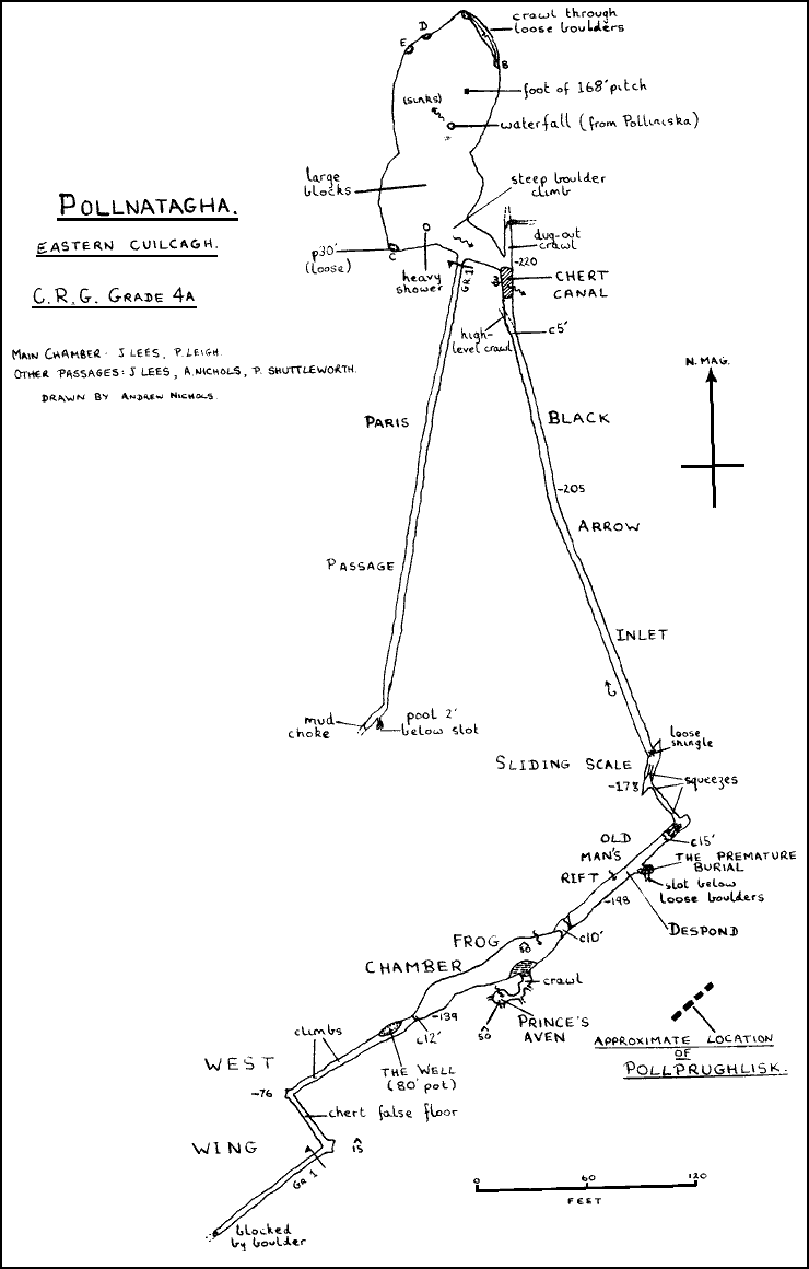
Polliniska and Pollnatagha lie on the edge of the peat bog which stretches along the eastern edge of Cuilcagh as far as the border with Cavan. The system is reached by the 'Turbary Road' - a natural limestone pavement which runs from the car park above the quarry, parallel to the edge of the scarp. The area was first investigated in 1947, by the Yorkshire Ramblers (1) who noted the line of five sinks along the side of the limestone track, and descended Polliniska, Pollnatagha and Pollprughlisk, performing grade 1 sketches. A second visit in 1949 (2) saw no further progress. The three caves had also been descended during the 1950's by Craven Pothole Club (3) who added nothing to Pollprughlisk but reported the find of an 'eighty-foot pitch' in Pollnatagha. Sporadic exploration has taken place by members of the Irish Caving Club (4) concentrating mainly on Pollprughlisk, which has had another large rift chamber added to it, though the depth has remained at 205 feet, as in 1947. We were told by I.C.C. that they had been unable to locate C.P.C's 'eighty-foot pitch' and that no-one had been down Pollnatagha for nearly three years. We decided that, in view of the proximity of other holes in the area, the distance to any apparent resurgence, the depth of limestone and the volume of water sinking, the system merited at least a descent, and possibly a survey.
Polliniska is the present sink of very large stream, Pollprughlisk, 350 feet away, representing an earlier swallet, though it does still take floodwater. Between the two is an abandoned streambed of worn and deceptively high quality limestone. Thirty feet east of Polliniska is the shell-crater entrance to Pollnatagha.
The entrance pitch of Pollnatagha was rigged and found to be 168 feet belayed to a very convenient frontier post some 40 feet away. John Lees, Pete Leigh and Gareth Jones made their intrepid way down. For the first 30 feet the ladder hangs near the wall in a jagged sided shaft, 8 by 15 feet, but then it hangs entirely free, a superbly exciting climb, a prominent sill marking the top of the chamber 100 feet from the bottom. The Polliniska water issues from a series of shattered cracks 50 feet below the sink to plunge down 20 feet from the ladder all the way.
The chamber is shoe-shaped, 165 feet long, 55 weet wide and 7O feet high below the main shaft. A floor of massive fallen blocks slopes up 15 feet to the south end, where a second waterfall lands after a 50 foot drop. The limestone is bedded in 9-inch layers alternating with 4-inch layers of chert. The three split up and explored the holes at the sides. The two 'ways on' marked by Y.R.C. at the N.E. of the chamber (A & B) were found to be opposite ends of simply an unsafe crawl between loose boulders. Hole D, though it seemed to have taken water, was simply a gap between boulders, some 10 feet deep, as was E. The Polliniska water usually sinks immediately, but on a later visit it flowed across the floor and down the 'sink' E. The remaining hole, C, in the south corner, was descended for a very loose 15 feet until the proportion of peaty clay to space barred progress.
Gareth now claimed to have found the way on. From the bottom of the second cascade, water made its way 60 feet down a steep slope of blocks to a short shingle-floored crawl. Halfway down, on the right, a muddy crawl was followed by Pete for 200 feet to a claybank, which was dug away to gain 10 feet of passage to a second clay choke: although the passage, which went steadily uphill, carries no water, a pool was noticed on the left below a passable slot. John pushed on along a rift passage for some 300 feet to a boulder and shingle choke; this is almost certainly the one that Y.R.C. (1) describe as being "a dry passage, followed south for 200 yards without difficulty against a strong air current". Their descent was in the middle of a drought and running water was reported to have been heard but not encountered. From the cascade, at the south end of the chamber a steep and wet climb down peaty blocks for 40 feet flattened into a short crawl, the water running over a clean shingle floor.
At the bottom the passage intersected a strong master joint, the water running into a waist-deep pool (the Chert Canal). On the left, the way was blocked by a cylindrical chert bridge and choked with shingle; on the right J.L. followed the Black Arrow Inlet for 270 feet of high crawl in a square passage made awkward by massive chert protrusions. A frenzied scrabble up a loose slope of shingle gave flat out access to a rift chamber, the Sliding Scale. A second frenzied scrabble replenishing the raw material for the first, led steeply up to the right, through a floor level thrutch and into a two-man chamber. The way on was a narrow rift on the left, running for 25 feet back along the main joint after the temporary interruption. Half-way along he noticed a block of wood, very water-worn, which was extremely unlikely to have journeyed from the Main Chamber, the Chert Canal being some 50 feet lower and several constrictions away.
At the end of this short crawl, the passage intersected a large high rift swinging to the right along the line of a small fault. A considerable amount of collapse had taken place and the way on was past a massive block to a 20 foot climb down, using the chert ledges as miner's stemples.
In contrast to the earlier part of the inlet, a thick peaty clay coated everything and this, combined with the disconcerting fragility of the ledges made descent entertaining. At the bottom, the rift appeared to close a few feet on, leaving only a short climb over and under a boulder fall to a small 'chamber' (the Premature Burial). A slot in the floor, choked by rubble, seemed to be the only way on, so after a little unsuccessful gardening, J.L. decided to call it a day. On his return, the survey of the main chamber was completed and all three struggled back up to the pitch.
Three days later the second assault got underway, Phil Shuttleworth and Jack Upsall planning to remove the obstruction to the left of the canal and to poke about generally, while John Lees and Andrew Nichols surveyed the Black Arrow Inlet as far as possible. Gareth was convinced that the inlet continued to the left, so J .U. and P.S. attacked the chert bar with lump hammer and chisel. A considerable amount of effort established that to cut through would take a week, so they turned to digging underneath it.
A brisk spell of gardening gave J.U. access to the 30' of visible passage and a little more enlargement allowed P.S. to follow. But 20 feet further on the flat-out crawl narrowed grotesquely, and digging in the gravel floor produced only a first sized hole. Half-way along, a high-level crawl was noted by P.S. who chipped away projections and entered it. After a few feet there was a pool on the floor which gave forth rank odours when disturbed and he retreated, coughing and choking, though the low passage continued round a corner. The two of them then laddered pot C in the main chamber and P.S. descended 15 feet to a crawl through mud and boulders, abandoned after a few yards as it was dangerously unstable.
Before setting off on the surveying, J.L. and A.N. prodded and kicked in the canal in an attempt to find the outlet, establishing that there were no holes in floor or wall and the bottom was a mass of jammed stones. However, when we descended a fortnight later, after heavy rain, the level had risen only a few inches, indicating that the sink is not badly choked; a little work with a crowbar might accelerate the drainage.
Fifteen feet beyond. the canal, the inlet steps up a few feet and looking back, A.N. noticed a body-sized crawl over a chert false floor which we left for the return and then forgot, though it might repay attention. Surveying was abandoned at the start of Old Man's Rift, because of time and mud, and we climbed down to look at John's "promising dig" (the Premature Burial). While A.N. nervously endeavoured to hold the boulder fall together, J.L. gardened like a mad thing and eventually succeeded in getting head and one shoulder into the floor-level slot. Beyond him the rift continued downwards, apparently widening, although a lump hammer would be needed to remove chert projections to gain access.
Before abandoning work, the two investigated a black hole 20 feet up which A.N. had half seen, though reaching it means crawling at floor level for a few yards before climbing up on the chert stemples - a somewhat hairy procedure, as even lumps four inches thick gave way without warning. At the top, the rift widened above a clay slope into an impressive aven - Frog Chamber - 100 feet long, 20 feet wide and some 50 feet high at the lower end. The walls were of the first clean limestone met in the pot, though we failed to see any corresponding band while climbing the big pitch. Apart from a small pile of clean rocks in the centre, the chamber was floored entirely with smooth clay, banked up at the sides in mounds of soft peat earth. At the far end a continuation was noted and, A.N's unsuitable footwear and faulty technique letting him down, J.L. chimneyed up the muddy 12 foot climb and into a passage. (the West Wing), 5 feet wide and 8 feet high. Almost at once the floor funnelled down in a blind pot which he gaily traversed, ignorant of the depth. Finding nothing exciting in the next 40 feet he returned and the two made their muddy way back to the main chamber and out, all four managing the big pitch on an average .5 of a gonk.
It was not until a week later that the club had exhausted all the local tourist trips and decided to descend the pot again. J.U., joined by Pete leigh, was to push all the other passages from the main chamber and the high level crawl beyond the Chert Canal, while A.N. and P.S. completed the survey from Old Man's Rift. Twelve hours' heavy rain had doubled the size of the Polliniska stream, which made the entrance pitch superbly impressive, as the last 130 feet were a few yards from a roaring column of spray. At the bottom, J.U. sat down to wait for P.L. (expected an hour later) and three hours later a helmet dangling on the lifeline woke him, alone, cold, stiff and very angry.
Meanwhile P.S. and A.N. grotted off with the surveying-gear and a ladder for the blind pot. The second cascade was very much heavier, though the Chert Canal had hardly risen, and the overnight rain was noticeable elsewhere; at the bottom of Old Man's Rift, a heavy shower-bath from the roof had turned the earthy floor into a thigh-deep morass (Despond). An even heavier shower landed on the pile of rocks in Frog Chamber, no doubt accounting for the absence of mud we had noted before, since the appalling floods of 16th August (Ireland's worst for 30 years) must have filled the Chamber with fresh peat. A.N. then got remarkably excited about an unusual formation on the mudbank below the north wall - a widespread but light drip had reached some of the stones embedded in the mud, and, as it washed away the exposed material, these rocks acted-as-umbrellas and now formed the capstones of a forest of mud pillars up to two feet high. They had definitely not been there last time and are presumably short lived. No sooner had he turned away from these, than his eye was caught by a yellow bounding object in the middle of the floor, Closer inspection revealed this to be an active frog (as in 'Chamber'), and, although it leapt quickly away, he ran after it long enough to see that its skin was slightly blanched and its eyes distended, combined with a general 'under-nourished' look. How or when it had descended that 160 feet from the surface is a mystery, though our amateur zoologists opined that it would be unlikely to have lasted the three weeks since the flood or to have found its way there from the Main Chamber.
After the 12 foot climb, the ladder was dumped and the West Wing surveyed. The muddy passage remained 3 to 5 feet wide, the roof lowering gradually until a small chamber was met after 80 feet. From here the continuation became a flat-out crawl over a chert floor for 40 feet, going off on the left at right angles to the previous direction. At the end this ran into a small chamber on two cross-joints, some 6 feet wide and 15 feet high; the passage swung back to its original bearing and continued as a narrow low crawl over blocks of stone. While A.N. climbed up into the roof of the rift chamber on chert ledges, finding it to narrow hopelessly, P.S. removed a few boulders to add 80' of straight crawl with a 15' blind pot a few yards along. A large block from the roof halted progress and after a few half-hearted efforts to get through the six inch gaps left at each side, he grotted back feet first and we made our way out, satisfied that we had reached the end of the inlet. This point is some 750 feet from the Main Chamber and 95 feet above the bottom of the ladder - less than 60 feet from the surface.
On our way back, P.S. rigged the blind pot with 30 foot of ladder belayed by friction and his sitting on the wire, while A.N. descended nervously on the end of the surveying rope. From an initial section 10 feet by 6, The Well plunged down in a gradually narrowing shaft until reaching down for the next rung, his feet met only C-link..
A quick look revealed substantial amounts of pitch remaining and a floor of a sort could be discerned another 30 feet below. However, this seemed to be just a ledge with the shaft continuing below, and he looked round for something to drop. The dearth of small pebbles was overcome by leaning acrobatically over and pulling large lumps of chert out of the wall. Half of these landed in mud at the first bounce, but those that dropped on the side away from the apparent bottom were more interesting .... "splat (first ledge) ..... rumble ..... clatter ..... splash". This indicated a landing on some sort of rock slope into a pool. We were told by I.C.C. that they had been unable to locate the '80 foot pitch' mentioned by Craven P.C., but this is almost certainly it; if their plumbing of the depth is correct, the water at the bottom is 30 feet below the bottom of the Main Chamber and some 20 feet above the Chert Canal.
On the way back through Frog Chamber, A.N. investigated a peaty bedding-plane hidden behind a mud bank on the south wall, unnoticed before, and was surprised to find a flat-out crawl dropping down to a clean shingle floor, A few yards further this swung to the right to emerge at floor level in a high, clean-washed rift chamber, Prince's Aven. The chamber was some 10 feet wide and a heavy shower (which sank immediately through the shingle and rock floor) made it difficult to see up, though the height must have been over 40 feet. Two crawls were noted going off along the joints some ten or twelve feet up and a further pair of turnings branched off the entrance crawl, but none of them were investigated - either lights were fading rapidly or the completely non-reflective black surfaces everywhere were affecting eyesight seriously. They returned to the Main Chamber and hurried up the pitch for the last time.
On plotting up the survey, we wished we had descended Pollprughlisk as well, since the connection is almost certain. The only survey of it so far is a good Grade 1 sketch by I.C.C. showing it to be 205 feet deep. The position of Pollprughlisk relative to the inlet passage is accurate to only 40 feet, but the bearings of the joint-dominated development are exactly the same. The lower chamber cannot be directly beneath Old Man's Rift, but it is extremely likely that they are either north-east of the end of that passage or on the parallel joint forming the last section of the West Wing. In any case, the connection to be forced can be no more than 60 feet, giving a short but quite sporting through trip. The most promising points of attack are a dig at the Premature Burial or investigation of the four unexplored crawls off Prince's Aven. A complete descent of the Well above Frog Chamber would also be worthwhile, especially if there is water at the bottom.
The sources and destination of most of the water are unknown; the Polliniska stream sinks hopelessly through boulders; the second cascade is assumed to be part of the same water, though it is 60 feet away and may not be. The three flood inlets in Old Man's Rift, Frog Chamber, and Prince's Aven are some 400 feet from Polliniska and very probably have a different source, though there is no other surface water. According to Cullingford (5), Peter Bryant's Hole, which is some 300 yards away and takes a considerable stream, is on the same master-joint as Pollnatagha Main Chamber; our resident surface party, Steve Smith, whiled away the time with a one-man-and-prismatic descent of the hole, performing a sketch which shows the development as exactly north-south.
Finally, there is almost certainly a third connection with the surface, by way of the West Wing. Y.R.C. noted that "periodic puffs of air rose up the shaft (of Pollnatagha) to form clouds of mist at the surface". Black Arrow Inlet draughts strongly inwards (though this decreases beyond Frog Chamber) and the same direction of flow was clearly shown by flood debris on our first descent. The frog, too, must somewhere have gambolled in the sunlight as a tadpole. The whole of the passage beyond the Sliding Scale is heading into the hillside and removal of the blockage at the end of the West Wing should provide the way to the surface; unfortunately, this probably calls for small applications of explosives, which the delicate political situation currently rules out.
A day was spent investigating some of the holes in "Ireland's Newby Moss" area, reached by the track from the quarry where vehicles are left for Pollnatagha. Legacurragh Gap itself is a steep dry valley which runs north-east below a limestone cliff. Behind the cliff is a large flat area of ling-covered clints containing scores of shakeholes; any serious exploration here must be accompanied by a detailed surface survey, since only three or four pots appear on the six-inch map. We had intended to do such a survey ourselves until we realised just how many shakeholes there were.
According to the 1962 Edition of British Caving, the strong masterjoint forming Pollnatagha and Peter Bryant's Hole is also responsible for Legacurragh Pot, but the rift-developed shakeholes were seen to point in all directions, though there is a second strong joint running south-west-north-east, along which Pigeon Pots 1 and 2 were formed. A few of the pots were descended, but none could be identified with certainty. The only surface water was that draining from the rise to the west.
The limestone is the same thinly bedded variety, alternating with soft chert Bands, as encountered in Pollnatagha and the neighbouring sinks, except that it was very much looser. Several times ladders were rigged down a slightly overhanging entrance rift and had to be re-rigged on the opposite side because of the extreme danger from falling rock. One such was Black Pot, where Pete Leigh, descending the 85 foot daylight pitch, tried to kick the ladder free from a narrow ledge - the couple of hundredweight of rock forming the ledge simply crashed to the ground. The pots descended differed only in size; formed on a single pitch from 30-100 feet descends past very rotten rock to a floor of muddy boulders; the boulder slope continues down and a second slope comes down from the far end; the boulders on the floor are of enormous size and, although there are holes between them near the walls, these choke quickly with the sticky peat clay washed down after every storm. The rottenness of the rock far exceeds anything encountered in England, and the first 20 feet of each shaft seemed to be constructed from a substance akin to slate with the tensile strength of rotten wood. There is little point in digging any boulder choke in the area. Only two caves were found worth a second visit; the first half-way up the hill beyond the Gap itself; the second, a railway-tunnel sized passage at the bottom of a steep scramble not pushed, through absence of light, but G.H.J. reported signs of phreatic development.
At the insistence of Gareth, several members walked vast distances across wet fields, peat bogs and enormously swollen streams (this was the afternoon of the Great Flood) to see whether the Pollahune stream sank in a small lake - as the O.S. Map seemed to indicate - or went round in a circle. The stream. together with the Sumera, Monastir and Sruh Croppa rivers, drains the north-west slope of the lower peak of Cuilcagh. We followed the brown flood water into the plantation, where the 10 foot deep trench in which it circles and sinks was full to the brim with slow moving debris; muddy grass in the tree tops showed that a few hours earlier the stream had backed up for a further 15 feet.
Examination of the flattened grass and bushes led us from the normal sink to a large boggy shakehole (B) where most of the surplus had gone underground at the foot of a 12 foot rock face. The shakehole had filled and the water risen some 15 feet to flow over the top and into a mass of mosscovered boulders (C). At the height of the flood, water had even rushed on from here to pour down a fourth sink (D) with a boulder floor at the same level as (B).
J,U.and A.N. wriggled in between boulders at (D) to find a narrow rift 5 feet deep going off to the right, which could not be entered except by moving the two or three boulders which held the place together.
P.L., G.J., and S.S. busied themselves with (D), a small muddy shakehole with one sheer rock face, giving forth a draught and the enticing roar of water. Frenzied efforts produced a 5 foot shaft of doubtful stability, but work was abandoned when someone found that only six hours remained till closing time.
Returning the next day, A.N., J.U. and P.L. found that the 'canal' to the main sink had dropped 8 feet to a small stream running flat over gravel to a rock and earth blockage. Half an hour's brisk work on the dig at D filled it with three large boulders and, joined by G.J. and S.S. we had removed these after two further hours to uncover a 20 foot shaft between stacked boulders. This was rigged with G.J. and a ladder and for ten minutes nothing could be heard but the most horrible oaths against a background rumble of moving rock.
The pitch entered one side of a 'chamber' 15 feet by 10, whose sides, roof and even floor consisted of loose boulders The rock face of the dig slanted disappointingly away, and the roar of water was reached by a crawl below airborne rocks to a streamway 4 inches high and 1 foot wide, which flowed uphill (in surface terms) towards the main sink. All six of us descended to view the "one dig in a hundred that goes". Last to go were P.L. and A.N.; P.L. pushed along a crawl through more loose rock for 15 feet to a hole in the floor which he enthusiastically started to enlarge. A clatter of shingle and rock was followed by a request for A.N. to be ready to haul him out by the feet if he could not extricate himself from the loose stone now encasing him from the waist up; A.N. had no option but to stay, as he had tried to scale the boulder pile in the middle of the floor and was even now sitting at the bottom as a stemple to prevent the whole mass from blocking up P.L.'s, crawl. When both were out and the noises had stopped, the shaft was immediately and joyfully choked.
Attention was next turned to the marshy shakehole B and a shaft dug down by the rock face at the north end. This was abandoned when the solidity of the boulders increased dramatically and the inflow of peat mud repelled the diggers.
Lastly the main sink was attacked. The water runs for 150 feet over gravel in an earth-sided trench, to sink between large rocks beneath a 10 foot high earth face. The ease with which the water could be diverted and the rocks moved, and with which the banks collapsed, make this a fairly hopeless prospect; the ground is simply earth studded with boulders, with no sign of bedrock. Perhaps extensive and skilfully shored tunnelling would achieve something, and it has great potential if solid rock could be reached. The presumed resurgence is Shannon Pot, though it may equally well be one of the risings near Blacklion. But a surface stream flows west across the bottom of the plantation and a dye test, if positive, would save much useless toil.
The limestone-shale boundary was thoroughly inspected across to the Sruh Croppa river, and it was established that there is only one sink between that and Pollahune. A large stream flowed down to an enormous 'lake' of gravel, over 100 yards long; water flowed across to sink through the shingle floor of a gravel sided hole 8 feet deep and wide, with no prospects at all. During the flood, the water had risen 10 feet above the surface of the 'lake'.
A hundred feet below the boundary, a long line of various sized shakeholes was investigated. None of them took any water, and all were fairly extensive collapses. Even the most promising of these necessitate long and arduous digging.
During one of the many halts in the digging at Pollahune, G.H.J. walked across to see if anything was to be gleaned from flood marks at these two nearby holes. Pollnaowen (W.7.3, N.9.6) was a hopeless prospect; the water filters down through boulders with no obvious point to dig. A pronounced flood channel led all the way from it to the bridge on the road by the White Cairn, indicating that any streamway is a trivial one not far from the surfacee. Pollboy (W. 7.2, S.12.6) had also overflowed, but to a lesser extent. The sink itself is uninspiring but a rift twenty yards downstream was descended 10 feet to a crawl blocked a few feet in. Loose rock makes the dig grim, but it may be worthwhile.
The size of the Main Stream Passage of Pollnagollum and the amount of water sinking in the bed of the Sumera river a mile upstream make this one of the most interesting parts of the Marble Arch system. Pollnagollum is separated from the top of Skreen Hill III by an extremely large boulder choke, and on a C.U.C.C. tourist trip by John, Pete and Andrew, J.L. thrutched energetically to establish that this choke was not one of the connections opened up by the floods a fortnight before (6). Pollnagollum ends upstream below the huge collapse of Polldownlong, and the three trogged merrily along to the boulder choke. J.L. continued to thrutch at water level and found that the draught had ceased; the connection with the surface was established by the strong draught down through the boulders, and P.L. was bitten twice by a gnat - though this may show that any hole opened up is merely of gnat size.
On the surface, Polldownlong was examined closely as various members wriggled down between boulders the size of cars; one such hole was descended for 15 feet to a small 'chamber', which held no promise and simply indicated the scale of the choke. Any attempt to dig at the sheer sides of the shakehole would be futile, but A.N. and J.U. were quite excited by a thin crack 10 feet from the east edge. Pulling back the grass from the edges, a 2 foot wide rift ws exposed and dropped stones put the depth at 30-40 feet. The rift is about 60 feet long and though it is simply a fracture caused by the (geologically) imminent toppling of a 50,000 cu.ft. block of limestone, the line of cleavage may be a weakness extending quite far downwards. Not having a ladder, the two had to content themselves with the rattle of stones.
A couple of hundred yards from Polldownlong is Pollasumera, a maze of interconnecting rifts of doubtful stability, which have not as yet been pushed to the level occupied by the Sumera river. We could see from the debris that, during the flood, the water had risen 70 feet above Pollasumera to sink amongst grass-covered boulders to the north. Mid-way between this and Polldownlong, a promising shakehole (approx. W.5.7, N.10) was noted and dug. Of the several small shakeholes nearby, it alone showed signs of activity - funelling down of the boulders had left a 2 foot wide band of earth below the rim on which the grass had not yet grown. The abortive dig showed that little could be done without a small hauling derrick and that the shakehole was still on the move. The site is an extremely promising one and, at 15 feet in diameter, so small a choke should go with the right equipment.
After the tourist trip down Pollnagollum, J.L., P.L. and A.N. set off on an extremely circuitous route to find the recently collapsed shakehole recommended by Hugh Holgate of I.C.C. The only feature of interest was a stream to the west which rises from a shingle choke below a wood. At the top of the wood, 60 feet higher and 100 yards away, the water flowed into a bedding plane 10 feet wide and 18 inches high, loosely obstructed at the entrance with flood debris and further in with shingle and small cobbles, not a difficult task to clear. From its rising below the wood the stream flowed north through a trench in peat for 200 yards to sink in a small but well compacted choke of rocks. This could repay attention, small though the stream is, since it almost certainly enters the Marble Arch system, the Skreen Hill - Pollnagollum passage a quarter of a mile away being the nearest feeder.
Recommended to us by Billy Shiel of I.C.C., this is one of the most infuriating in the area; a line of shakeholes runs from the sink, most of them now abandoned digs. The nearest resurgence (Hanging Rock) is a mile away. Several clubs have been defeated by the hole and we added one more to the list. J.L., P.L. and J.U. located it at the second attempt and cascaded down an extremely loose boulder slope to a squeeze at the bottom, where gardening is necessary on the way in and great care on the way out. Beyond, a small chamber with a waterfall leads off by a tight squeeze to a 6 foot drop, the water taking a lower and impenetrable course. From this a tight and awkward tube was negotiated by J.L. for 20 feet to a squeeze which has so far stopped all comers, though it intersects, at roof level, a passage where the stream can be seen flowing to the right along a large passage 10 feet below.
A short-lived attack with chisel and lump-hammer was made by J.L., the four-inch swing with the latter showing him how the pot got its name. J.U. then replaced J.L. and made equally little impression; removal of a 3 foot bulge 3-4 inches thick is called for, and there is no joint, crack or lump for a chisel to work on. The three made their way out, bewailing the fact that either the suicidal pygmy at work in Pollnamansh, or the first person to get an explosives licence in Ireland, will have anything up to a mile and a half of passage handed to him on a plate.
Yet another of G.H.J.'s "promising caving areas" wasinvestigated, the Lough Navar Scenic Forest, where the O.S. half-inch map marked four streams sinking behind the top of the 900 foot escarpment south of Lough Erne. In fact the whole of the plateau is over grit, and the 'sinks' are merely where the streams run into peat bogs. John Lees, Gareth Jones and Steve Smith walked west from the Viewpoint for a mile or so to a dry limestone valley. A stream sink was found to be badly choked, and the few shakeholes hopelessly filled with mud and vegetation. No prospect in the area.
Disillusioned with the old, old story from Jones the Grit, Pete Leigh, Phil Shuttleworth, Andrew Nichols and Jack Upsall journeyed along to the Knockmore inlier where we knew there was limestone. The inlier is north of the Garrison - Derrygonelly road, and runs westward for half a mile from Poulnamuck. (Ferm. 14, E.16.7, S.5.8). Although dismissed by G.H.J. later as the 'Burrington Combe' of Ireland, several promising holes were noted.
The inlier is a heavily folded knoll rising about a 100 feet from the surrounding grit; to the south are the great limestone scarps and plateaux containing Pollaraftara, Reyfad and other notable holes; to the north, the ground drops steeply some 300 feet to a strean, which sinks almost immediately. The side of the valley swings round in a curve to the east and at its foot are a number of small caves and resurgences.
This lies in a shakehole at the end of the dry valley running parallel to the road. Short investigation by various members established it as a tight and long-abandoned upper series, so choked with infill that the several old digs noticed there could have little promise.
A walk over the top of the inlier located several possible entrances to Chapel-le-Dale type sub-surface crawls, though most of them seemed to choke immediately with dry peat. A shakehole (approx W.15.5, S.6.5) in a dip at the west end exhibited twin shafts with delicately rippled sides descending at least ten feet and led us to return later with vast amounts of tackle. The east shaft was rigged and descended by J.U. and then A.N., a 20 foot climb down extremely sharp rock-blades to a chamber barely big enough for both of them. The shaft widened to some 6 feet but was choked with boulders too large to get out through the entrance. The ladder was swapped to the second shaft 5 feet away and P.S. descended by the very tight entrance. This too went down 20 feet and ran back under the shakehole as a narrowing rift, chokedat thebottom. Lump hammer and chisel failed to give access to the cross rift glimpsed, and a certain amount of amusement was caused when P.5. found.that the pitch was too narrow to climb up and that he had to remove NiFe Cell, helmet and some of his clothes before a strong lifeline could get him out.
Wandering aimlessly over the peat, A.N. noted what seemed to be a stream descending the escarpment to the south and deduced that, as the valley was dry, a sink must be at hand. This was locatedin a bush lined hole 300 yards from the road where a small stream disappeared through boulders on the right, leaving a slot on the left about 7 inches wide. A distasteful discovery was that what had been taken to be curious open air flowstone was in fact an evil smelling gunge; though some claimod it was innocent peat mud, the rest traced the water up past the house on the roadside and decided to call the hole Pollnamansh (as in 'avens', Swildon's IV).
An outright refusal by P.S. and J.U. and considerable reluctance by A.N. to grovel on his face in the deposit necessitated forty minutes' work on the entrance with the pickaxe, which removed an offending knob of rock widening the squeeze to 8 inches, but did nothing to keep A.N.'s. face out of the mansh. The slope dropped 3 feet into a triangular crawl obstructed by a flake, and more easily passed feet first. A 3 foot drop, and our intrepid explorer found himself in a chamber 7 feet high and 10 feet long (the Cistern). A pool of water on the floor was constantly replenished the stream, which spurted in waist-high from a crack in the rock.
From the chamber the water flowed along a low crawl and A.N. went out to don his wet suit, returning with J.U. Together they grovelled down the crawl to a left hand bend where the rock haded at about 60 degrees and the water had cut a curved cross-section to a narrow trench on the outside of the curve. The resulting squeeze presented a choice between a shallow tube 7½ inches high or, to the right of a knob of rock, the slighly tighter trench taking the water. J.U. tried to go to the left of the knob and, after much leg-thrashing, retired defeated; A.N. made similar motions with the lower squeeze but failed to penetrate further than two-ears and one shoulder. The two abandoned hopes of the Knockmore Master Cave and crawled out to put antiseptic on their wounds.
Next to arrive were Gareth, Steve and John "call me superhero" Lees; A.N.: and J.U. proved remarkably uncommunicative and so S.S. and J.L. donned lights and wriggled in. Although S.S. remained in the Cistern to keep his clothes dry, J.L. pressed on and - without noticing it, so he said - passed the squeeze which had halted the previous two. In fact J.L later admitted that it was a trifle tighter than the present Black Shiver squeeze and vastly more awkward. He carried on down a small drop into a pool and followed the wet, tight and twisting passage for some 80 feet beyond the squeeze. He was halted by a sharp left hand corner down 3 feet to a narrow pool with more water than airspace; from his viewpoint it looked like a sump and, dressed as he was in plimsolls, jeans and T-shirt, he decided to leave it. Ironically, he got soaked on the way out. Those outside decided J.L. had been down far too long for the known 15 feet, and J.U. was inserted to ferret him out. He was located in a nicely decorated chamber noticed on his right above the stream passage. The Pleasure Dome was 12 feet high and covered in fine brown and white flowstone, floored with calcited boulders. J.L. climbed up to ascertain that it did't go anywhere, though inspection of the surface showed it to be directly below a small shakehole. The two heroes then thrutched back out, and plans were made for a return fixture.
Four days later, John, Phil and Jack crawled down to push the pool. An airspace was found over 2 feet of water and J.L. surged forward, finding the pool a little over 10 feet long. Beyond, the passage stayed 3 feet high and began to narrow, the floor covered with a curious assortment of gin-traps and other rubbish. A muddy squeeze led to a second long pool (the Canal) and he struggled through to find that the passage narrowed abruptly to a slot, beyond which a pool continued 2 feet lower down. All three returned to the entrance and collected a lump haimmer, chisel and other odds and ends. P.S. and J.L. set to work on the final squeeze but abandoned the task after twenty minutes; it is reported to need a pygmy contortionist who is willing to squeeze head first into water and not be sure of getting out. Meanwhile J.U. performed a survey and took a few photos - a difficult procedure, as the tightness of the passage made it impossible to unpack his camera at several sites.
The present length of Pollnamansh is 120 feet and the survey shows that, instead of going north-east into the hill as we had hoped, it in fact runs east along the dry valley some 15 feet below ground. Two hundred yards along the valley is a collapsed shakehole where water can be heard, and presumably this boulder fall blocks the downstream passage of Pollnamansh, since flood marks showed on our second visit that water had welled up out of the shakehole and back down a small rift a few yards further on. Pollnamansh, despite its shortness, is extremely sporting and it takes a good hour and a half to get to the end and back; the squeezes are of a very high standard and anyone of more than average caving girth will be unable to do more than the first 20 feet, even if he should wish to.
Though not dye-tested, the water almost certainly resurges in the main valley to the north, between 3 and 400 feet lower. There seems little point in pushing Pollnamansh itself, but there are plans for digging the in shakehole to the east for access to the passage downstream of the presumed boulder choke. The old sink and high-level development of Poulnamuck consists of two narrowing rifts which, choked with clay infill, have no future. But the steep hillside to the north east and the abandonment of Poulnamuck itself indicate that shortly after the collapsed shakehole the cave must descend rapidly through the considerable depth of limestone below it.
Coleman, "Caves of Ireland" p.62 says that "the 1856 edition of the six-inch Ordnance Survey Fermanagh sheet 20 marks at least eight swallets in the triangle between Lough Nacloyduff, Pound Hill and Lough Muldberg. The whole area is within the sandstones and shales and the swallow holes may show local thinning." Several disillusioned members of the club returned from a long cross-country walk - even being so foolish as to take a NiFe - cell, pickaxe and digging rope - ably led by Jones the Grit, which established that even the two places where the surface stream comes to a halt have no association at all with cave phenomena. The swallow holes simply do not exist.
Yet another of G.H.J.'s 'promising caving areas' was the scene of a straggling trudge across-peat bog, this time the two southerly of the three limestone inliers shown by Coleman in his small-scale map on p.50 of 'Caves of Ireland'. Further support was that G.H.J.'s. halfinch map ("That's the last time I buy a cheap-Japanese copy.") showed three swallets in the same area. The three swallets, in fact, were simply peat bogs into which the streams ran. The limestone inliers just do not exist; the only alien rock in so many square miles of grit was a lump of limestone a hundred yards square by the edge of Lough Formal.
The large rising at the base of the escarpment behind Blacklion (Cavan 2 : W.10.5, S.5.5) was the site for frenzied digging by John Lees and Pete Leigh, abandoned when a boulder the size of a small car threatened to fall on the diggers. (What they really needed was SHEERLEGS...) Water issues from between boulders, and a 6 foot shaft was opened from the highest point of the collapse to finish an estimated four feet above the stream. It is difficult to tell how far back the boulders extend, but they are debris from the steep rock slope above, not a collapse at the entrance. If a way in can be found, prospects are good, since the rising is a sizeable one and the source a considerable distance away. Andrew Nichols and Jack Upsall spent an afternoon systematically examining the ground for some two miles uphill to the south and found no sink. The land rises steeply to a flat area of farmland and then develops into two dry valley bounded by clints. The west valley levelled off into a peat plateau and then dipped to the bottom of the young plantation in which the Pollahune stream sinks on the shale boundary nearly a mile higher up. The east valley ended in a less pronounced dip below a small limestone cliff, in which three earth-choked caves were found; pre-glacial in origin, their total length was about 60 feet. Below the cliff several shakeholes were investigated, only the two largest meriting a serious glance, and they, though in limestone were solidly choked with a large number of grit boulders. The clints in the top half of this second valley were devoid of holes, and a line of hopeless depressions led down to a large shake-hole a few hundred yards above the fields. Tree-rimmed and some 40 feet square, it is conspicuous for being the sink of the only surface water, a tiny stream. Its origin is plainly a collapse of the thinly bedded limestone, and a great deal of work would be needed to make any impression. A hopeful point is that there is still a considerable distance and depth to go to the rising and there are no more shakeholes or other surface collapses between the two. The source of the water must be sought above the two dry valleys; the surface gradient to the Pollahune sink is a very favourable one, though that would provide only a third of the water at the resurgence. The system is high on our list of digging sites for our next visit in 1971.
References
(1) Yorkshire Ramblers Club Journal 1947 vol. 7 pp.238,266.
(2) Y.R.C.J. 1949 vol. 7 p.312
(3) Craven Pothole Club Journal 1952, Vol. 1
(4) Irish Caving Club Journal, Spring 1970.
(5) British Caving, 1962.
(6) 'Descent', Vol. 14 p.15.
Note: The map references are given by the same method as Coleman in Caves of Ireland ie. measured in inches from the nearest edge. The maps are the Ordnance Survey Six-Inch series for Cavan and Fermanagh.
ANDREW NICHOLS, C.U.C.C.
| CUCC Home | ||
|---|---|---|
| Previous: So you think you're hard, eh? |
CU 1971 Contents Page | Next: Rear End Paper Photo |