| CUCC Home | ||
|---|---|---|
| Previous: The President's Bit |
CU 1971 Contents Page | Next: Cave Registries |
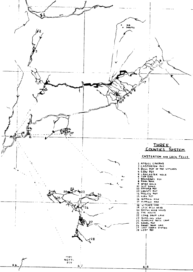
BROADLY SPEAKING, the Three Counties System extends from Aygill in Barbondale (Westmorland), through Leck Fell (Lancashire) to Gragareth and Kingsdale (Yorkshire), and possibly further south-east to Chapel-le-Dale.
Here is an outline of each pot in the presumed line, and the reasons why they are considered as part of the system.
Over 5,000 feet in length and about 200' deep. The entrance lies some 300 yards upstream of the junction of Aygill Beck and Hazel Sike, on the north side of the stream. The pot's dry and complex entrance series involves crawling and route-finding, until one passes through an inverted keyhole into a traverse and to a chamber. This is the top of the 30' first pitch, and at the bottom a large dry inlet passage enters which quickly chokes. A way down behind a slab leads to more crawls and the second 50' pitch. The main stream passage is soon reached, extending a fair length in both directions; downstream, it sumps several hundred feet from thc upstream end of Bull Pot of the Witches. Dye tests have established that the water enters Bull Pot: (1) and (2).
Over 5,000' long, 210' deep. The entrance, on the track from Bull Pot Farm, is a large open pot 40' deep, a stream falling down the north end. (Duncan Baldwin of the Red Rose Cave and Pothole Club has produced a good survey, and copies are obtainable from Bull Pot Farm). Descent without a ladder can be achieved by a side passage 20' down the open pot, and the stream at the north-west end, which sinks between boulders, is followed through several large chambers to the main streamway. The upstream section (from Aygill) sumps, and, downstream, ducks lead to a junction. On the right, a large passage continues dead straight, a hole on the left after 200' leading down to an inlet (from the south-east end of the open pot) and the main stream. In the top passage, there are more holes in the floor further on which can be descended to the main stream again. Down with the stream from the junction, a complex series of boulders, passages, false floors, chambers and so on leads to a larger chamber. Here, a crawl on the left at waist-level enters a further chamber, where a roomy passage on the right leads to the large and impressive final sump, the main stream reaching it on the right from the larger chamber. The sump is a 350' dive through to the East Branch of West Montague Passage in Lancaster Hole. The many passages in Bull Pot of the Witches 3-level complex are best understood by a trip down the pot before referring to the Baldwin Survey (2).
Over 10 miles long, 265' deep
Before any discussion of the system, the issue of the altitude of Leck Beck Head must first be clarified - or confused! Lost Johns' has been surveyed with fair accuracy to 500' deep, putting its sump 50' lower than the level normally accepted for Leck Beck Head, 700' O.D.; this gives Lancaster Hole a potential depth of 275'. Much has been said about the possibility of Lost Johns' resurging downstream of Leck Beck Head in the bed of the beck, and on the Leck side the limestone ends some 1000' from Leck Beck Head and 60' to 70' lower down. If the Lost Johns' sump is, in fact, 50' below Leck Beck Head, this must be what happens, as even Harry Long would have difficulty explaining where else it could resurge.
Recently two clubs did independent surface surveys between Lancaster and Leck Beck Head and produced the astonishing result that the level of the latter is 708' OD or 715' OD. This means
The water from Lancaster probably joins with water from Pegleg Pot, Kirk Pot and Witches cave before reaching Leck Beck Head; it is possible that the water from Pippikin Pot and Nippikin Pot connects with the flow at a different point, but probably it enters with Kirk Pot water. In any case, the water from Lancaster Hole, Pegleg Pot, Kirk Pot, Witches Cave and Pippikin all resurges at Leck Beck Head, and in each case has a small distance to drop before doing so (3).
Is a little above Leck Beck Head; a large resurgence in wet weather, it has been dived to a depth of 100'.
Several hundred feet long and 120' deep.
Over 2,000' long and 130' deep. The story from the Westmorland part of the system is completed by:
Situated a little higher on the fell from Lancaster Hole, it has a large entrance, 60' deep at the south-end. After a narrow and complex upper series it joins the main system at Fall pot.
A little-visited pot a few hundred feet north-west of Bull Pot Farm. The bottom of the pot is a little above the sump levels of Aygill and Bull Pot of the Witches, and presumably connects with the undeiwater passage between the two. A possible site for further exploration.
Two and a half miles long, over 300' deep. The size and age of this system adds new weight to the Three Counties System, one of the weaknesses of which was the lack of a passable connection between Leck and Casterton Fells. If the water from Lost Johns' does indeed resurge below Leck Beck Head (except in flood - see LOST JOHNS'), it may reasonably be assumed that a through trip from Lancaster to Leck Fell was never possible. But now there is a distinct possibility that Leck and-Casterton can be connected quite independently of the Lost Johns' System.
The discovery in Pippikin could be important in the following postulated connections:
(a) A large phreatic passage is seen in Gavel, well above Lost Johns' Master Cave, but apparently not formed by water from Short Drop Cave. Gavel's large passage is more acceptably considered in conjunction with the size of passages found in Pippikin - 60' high and wide - which, though more than 100' deeper, are a fair distance away. The south-west end of the large passage in Pippikin lies in close proximity to a fault, and the 20' by 25' phreatic passage in Gavel runs parallel to the one in Pippikin, but up-fell of it.
(b) At the bottom of Pippikin the stream from Red Wall Chamber runs towards Casterton before turning back and flowing parallel to the Easegill (Dry) Beck between Leck and Casterton Fells. But a dry passage continues onwards under the beck, some 50' - 100' below it.
The Happy Wanderers are at present trying to locate on the surface a mud, earth and grass-filled bedding plane at this point, which they believe may provide an easier entrance.
(c) At the bottom of Fall Pot in Lancaster Hole, if you traverse a few feet upstream in the Master Cave, a passage on the right can be entered which, 300' long to a calcite choke, runs away from any known part of the Lancaster - Easegill system. This passage is trending towards Easegill Beck and is more or less in line with the one in Pippikin.
Over 3 miles long, 500' deep. It has been noticed that, in flood, a sudden increase in the volume of water, over and above that expected, occurs at Leck Beck Head; this is thought to be an overflow from Lost Johns'. The theory is that the water-connection is effected when Lost Johns' backs up sufficiently to close a normally dry (but possibly syphoned) loop between it and Leck Beck Head. This 'loop' was the theory explained in Descent; the possibility of an alternate and perhaps extensive series of passages up fell of Lost Johns' was not really entertained until Pippikin. (4).
The pot joins the Lost Johns' Master Cave at Rumbling Inlet, almost directly beneath Masochist Passage and its junction with the main streamway in Short Drop; only a few feet of sump separate a through-trip. (4).
These two systems connect, and Masochist passage may be an old inlet; a high level search may connect the two. Quite possibly, Short Drop has a connection with the entrance series of Lost Johns' - this system alone would be nearly 6 miles in length. The series above Lyle Cavern in Lost Johns' probably has little to do with Ireby Fell Cavern - though I once thought it had - and, unless one can be sure that Notts Pot will at last let its passages run beyond the four ways down, it is difficult to furnish an explanation. Here I refer to the Fourth Way Down, the continuation of which ends beyond the terminal sump. Water can be heard dripping beyond the chamber at the end; this may provide a further clue. Perhaps it was once the origin of the extension to Lyle Cavern, as both passages are old and large.
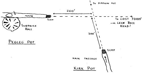
Some 2000' long, 130' deep. The entrance, recently dug out and stabilised by RRCPC, lies on the Leck side of the beck, just upstream of a 10' waterfall (though the beck here is normally dry). A 4' deep lenticular tube joins a similarly shaped horizontal passage which, after two acute bends, breaks into a passage like a railway tunnel, 10' x 10', both arms of which are some 20' long. A duck under a rock curtain on the right leads to a pool and bedding plane to the top of a 20' climb. At the bottom, a large collapsed passage runs back towards the beck and a dry choked inlet. An undercut vadose trench on the right leads round to a well-developed rift (though an easier route is a climb over the top of boulders to a drop back down) which, increasing in height, continues beneath two inlet avens, connected at the top. After two oxbows, a traverse is necessary over the top of a 70' pot - there are more ways off at the bottom and turning right, the way on is down a smaller rift to the muddy top of a 24' pitch. A largish chamber at the bottom slopes down to the head of a 15' climb into a further, choked chamber. The way on is a tube on the right at the top of the 15' climb, a hands and knees crawl to a flat out section where you turn left at a cross-junction. This shortly breaks out into Surprise Hall, a large chamber with a perfectly flat roof and mud banks all round the rim.
At the far end, a very large passage is found, 20' high and 10' - 15' wide. A small stream enters from the roof, and a 15' climb down to the floor of the passage leads on the right to an extensive sump. Upstream to the left the passage develops a phreatic roof - which has possibilities - and a passage on the left some 100' long leads to a 20' pitch; water enters the chamber below from a sump at the upstream end to flow into an impossibly low bedding plane. Continuing along the main passage, there is more mud to a downward sloping bedding plane, which, after two climbs of 8' and 10' and a descending corkscrew, leads to a narrow dug-out tube connecting with the main stream. Downstream, this stops almost immediately, but upstream it divides, the larger inlet being a bedding plane similar to that at the bottom of the 20' blind chamber. It should be noted that the stream in Surprise Hall is a different one from that found below the 70' and 20' pitches and at the end of the dugout crawl. Digging below the 20' pitch or in Surprise Hall, or investigation at high level in the streamway before the 70' pot or in the secondary stream passage to the right at Surprise Hall should all be worth while.
Some 500' long, 120' deep. The entrance is on the Leck Fell side just below the 10' 'waterfall' mentioned above. A rift crawl in the hole furthest downstream leads to a junction; turning left, a bedding plane with several climbs reaches a 50' pitch into the main passage. 20' square, this chokes upstream and ends at the lower end in a choked sump. The line of this passage is almost at right angles to the secondary streamway in Pegleg Pot, and at virtually the same level.
Interestingly, the sump in Pegleg appears to lower easily and so may not be very long. A harder question is, what happens where the two passages meet? It is quite possible - though again conjecture - that the downstream end of Pippikin may flow in along the Kirk Pot line, the three combined waters then continuing along the line of the Pegleg passage.
Ireby flows into Notts through a sump off the chamber above the 16' last pitch in Notts. The big question is, where does the combined water go to? Does the water flow to Leck Beck Head? If so, is the path up-fell or down-fell of Lost Johns'? The relative positions suggest a down-fell flow but then difficulty arises as to whether the water resurges at Leck Beck Head at all. The size of the passages in Ireby II and Pippikin suggest a fossil high-level system which as yet has merely been touched at each end, and it may be that both were formed by the same stream.
This means that Duke Street II will continue eastwards before going north again to Leck Beck Head, forming part of the Pippikin system on the way. My personal preference is that Notts water flows east (upfell) of Lost Johns' and passes between it and Pippikin, probably along one of the small faults which occur there. Whether upfell or downfell, it must connect either with Lost Johns' Master Cave, underwater, or with Lancaster water behind Leck Beck Head. It still adds to the main system in either case, but the latter will mean that through-trips involve marathon dives. (5), (6).
The N.C.C. claim that LOW DOUK (SD 678.768) connects with Ireby II via the Inlet sump just beyond sump 1. This is not proved by dye-tests, and it may instead connect with Red Rose Inlet series, or the inlet lower down Ireby, or even with Keld Head; certainly it doesn't resurge elsewhere, since Low Douk floods considerably and no independent resurgence can deal with such a flow. Ideas for further extensions towards Kingsdale must focus on Duke Street; this large passage, choked some 100' upstream of the point of entry in Ireby, is probably an abandoned main feeder from MARBLE STEPS, through which Marble Steps flowed to Leck Beck Head - in contrast to some previous ideas. That the Marble Steps water formed Duke Street is fairly certain, because:
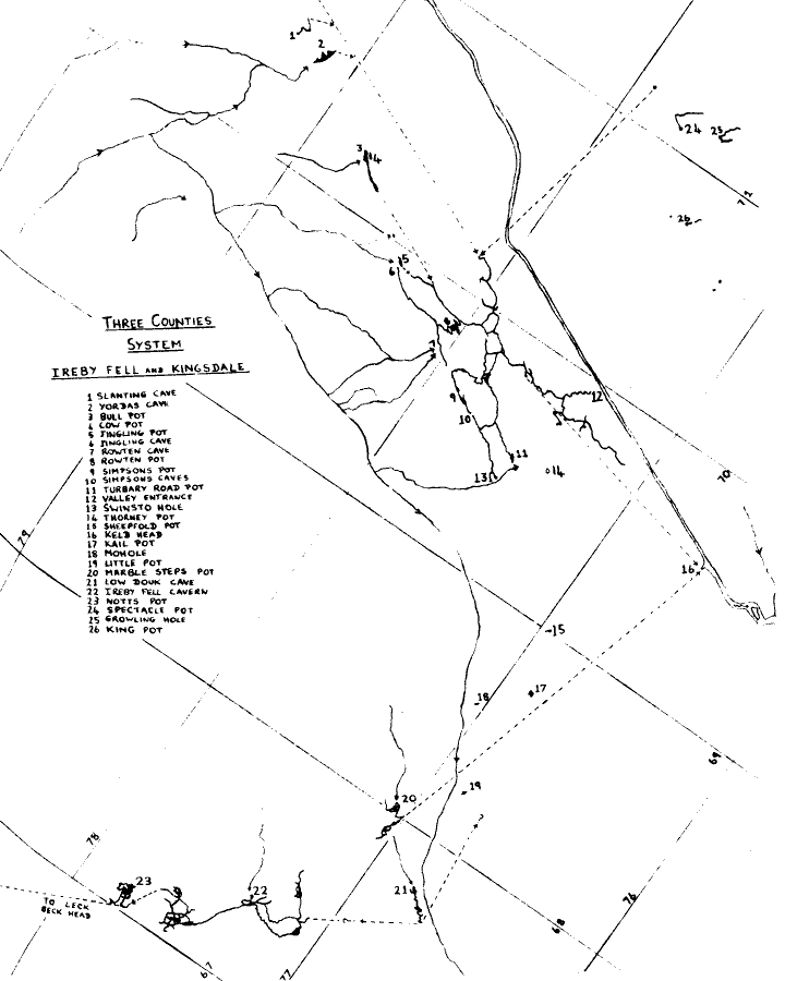
The water flows from Marble Steps to Keld Head with, according to flood pulse work, at least ¼ mile of passage having an airspace. According to Mike Wooding, his recent 1200 foot dive in Keld Head took him along the Marble Steps inlet and almost reached a continuous airspace.
More conjecture - how was Kingsdale Master Cave's Milky Way formed? Was it: (i) an old inlet from some of the shakeholes on East Gragareth? or (ii) an early route for the water from Marble Steps? or (iii) an old resurgence passage for the Master Cave, formed during the glaciation period?
Of these, the first is the most likely. (iii) is unlikely, since the passage is not phreatic (as it might be if, like the Valley Entrance, it was an old resurgence). (ii) is unlikely, because it is too small to have been formed by a large flowing stream. For these reasons I believe that the Milky Way and Carrot Passage were formed by several small streams from the surface, which have now mainly abandoned it for lower passages. However, the far end of the series is trending downwards, and it may join the sumped connection from the downstream end of the Master Cave to Keld Head, or with the Marble Steps Inlet, or may even have formed a second 'valley entrance' further down the valley.
It is already accepted that BULL POT, COW POT, and JINGLING POT connect with the ROWTEN inlet in the Master Cave, and that BATTY WIFE, SLANTING and YORDAS CAVES connect with the Deep Rising of Yordas Inlet in the Master Cave (8).
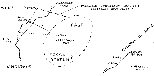
Recently a sink near SPECTACLE POT (SD 711.778) was dye-tested to Keld Head, almost certainly entering by the Deep Rising and flowing down the Master Cave (though unfortunately no-one was below ground at the time to see it). This poses another problem - where do the other pots on East Kingsdale resurge? None of these other pots have been successfully dye-tested but it is probable (though by no means certain) that some resurge at GODS BRIDGE (SD 773.764).
Does this then mean another fossil system extending beneath East Kingsdale, or is there another West Kingsdale-type Master Cave? It is hoped that a passable connection exists between the caves of Kingsdale Head and East Kingsdale - this would realistically extend the potential of the Three Counties System as far east as Chapel-le-Dale. It is then possible to go on to talk of Meregill, Black Shiver and the west side of Ingleborough.... but so far this dye-test is the only base for such lofty ideas, and this part of the system is probably best left until more evidence has been gathered. But a few pokes and proggles around Kingsdale Head could be very worthwhile. There are too few caves there so far.
Whether the answer is several huge systems or one COLOSSAL one, a lot of work remains to be done. But the following may realistically be expected as Large Systems Connected Passably and Without Sumps.
This report is composed of varying proportions of proven fact, scientific reasoning, guesstimation and plain pipe-dreams. But there is ample evidence for two or more systems of over 15 miles in length; nor is it a vain hope that there is one vast system whose ramifications total well over 50 miles.
| Aygill Cavern | 6,000 feet |
| Bull Pot of the Witches | 6,000 feet |
| Cow Pot | 600 feet |
| Lancaster - Easegill | 10 Miles |
| Pegleg Pot | 2,000 feet |
| Kirk Pot | 500 feet |
| Pippikin | 2½ miles |
| Lost Johns' - Gavel - Rumbling | 30,000 feet |
| Notts Pot | 3,000 feet |
| Ireby Fell Cavern | 2½ miles |
| Low Douk | 2,000 feet |
| Marble Steps | 3,500 feet |
| Mohole, Kail, Little Pot, Sheepfold Pot | 200 feet |
| Kingsdale Master Cave | 4½ miles |
| Bull Pot, Cow Pot, Jingling Pot | 1,000 feet |
Total length of discovered passage = 30¼ miles
The potential length of the system may safely be doubled to a figure of some 60 miles.
References:
(1) Gritstone Club Journal: Barbondale, 1966.
(2) Red Rose Cave and Pothole Club Journal No. 5, 1970.
(3) Cave Research Group, Vol. 9, No. 2 - Lancaster Hole etc.
(4) Tony Waltham's Survey of Lost Johns' and the Caves of Leck Fell - Happy
Wanderers Potholing Club.
(5) D. Brook - Ireby Fell Cavern Survey (ULSA) (to be published)
(6) D. Brook - Notts Pot Survey (ULSA) (to be published)
(7) D. Brook - Marble Steps Survey (ULSA) (to be published)
(8) D. Brook - Kingsdale Master Cave Survey (ULSA) (to be published)
(9) "3 - Counties System", J. Latham, Descent No. 7.
(10) "3 - Counties System", D. Brook, ULSA Explorations Journal - October,
1969.
JOSEPH LATHAM
Vice President
University of Leeds Speleological Association
| CUCC Home | ||
|---|---|---|
| Previous: The President's Bit |
CU 1971 Contents Page | Next: Cave Registries |